Reifenberg geodata
Reifenberg (Rheinland-Pfalz) is a seat of a fourth-order administrative division; located in Germany in Europe/Berlin (GMT+2) time zone. With population of 840 people, there are 7742 cities with bigger population in this country. Compared to other cities in Germany, 79% of cities are located further ↑North; 86.8% of cities are located further →East and 69% of cities have lower elevation than Reifenberg. Note1


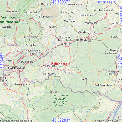
Reifenberg GPS coordinates[2]
49° 16' 58.188" North, 7° 30' 34.488" East
| Map corner | latitude | longitude |
|---|---|---|
| Upper-left | 49.73937°, | 6.80645° |
| Center: | 49.28283°, | 7.50958° |
| Lower-right: | 48.82203°, | 8.2127° |
| Map W x H: | 102×102 km | = 63.4×63.4mi |
| max Lat: | 55.01917° ⇑79% North |
| Reifenberg: | 49.28283° |
| min Lat: | ⇓21% South 47.40724° |
| min Long | Reifenberg | max Long |
| 5.92978° | 7.50958° | 14.98853° |
| W 13.2%⇐ | ⇒86.8% E |
Elevation
Elevation of Reifenberg is 351 m = 1152 ft, and this is 101.9 m = 334 ft above average elevation for this country.
| Max E: |
1256 m = 4121 ft | 31% |
| Reifenberg | 351 m 1152 ft | |
| Avg. | 249.1 m = 817 ft | |
Min E: |
-5 m = -16 ft | 69% |
See also: Germany elevation on elevation.city.
Geographical zone
Reifenberg is located in North temperate zone (between Tropic of Cancer and the Arctic Circle). Distance of this North polar circle is 1921.4 km =1193.9 mi to North.| Distance of | km | miles | from Reifenberg |
|---|---|---|---|
| North Pole | 4527.3 | 2813.1 | to North |
| Arctic Circle | 1921.4 | 1193.9 | to North |
| Tropic Cancer | 2873.8 | 1785.7 | to South |
| Equator | 5479.7 | 3404.9 | to South |


Nearby cities:
15 places around Reifenberg: (largest is in red/bold)
• Battweiler
3.4 km =2.1 mi,  261°
261°
• Biedershausen
4.2 km =2.6 mi,  333°
333°
• Dellfeld
6 km =3.7 mi,  205°
205°
• Herschberg
3.7 km =2.3 mi,  48°
48°
• Hettenhausen
6.3 km =3.9 mi,  27°
27°
• Höheischweiler
6.2 km =3.9 mi,  151°
151°
• Höhfröschen
5.5 km =3.4 mi,  131°
131°
• Knopp-Labach
5.7 km =3.5 mi,  352°
352°
• Maßweiler
2.5 km =1.6 mi,  136°
136°
• Rieschweiler-Mühlbach
5.5 km =3.4 mi,  187°
187°
• Saalstadt
4.8 km =3 mi,  37°
37°
• Schmitshausen
2 km =1.2 mi,  15°
15°
• Thaleischweiler-Fröschen
5.6 km =3.5 mi,  108°
108°
• Wallhalben
3.9 km =2.4 mi,  12°
12°
• Winterbach
3.5 km =2.2 mi,  310°
310°
Sources, notices
• [Note1] Compared only with cities in Germany existing in our database
• [Src1] Map data: © OpenStreetMap contributors (CC-BY-SA)
• [Src2] Other city data from geonames.org with taken over terms of usage.
• [Src3] Geographical zone / Annual Mean Temperature by Robert A. Rohde @ Wikipedia
