Maßweiler geodata
Maßweiler (Rheinland-Pfalz) is a seat of a fourth-order administrative division; located in Germany in Europe/Berlin (GMT+2) time zone. With population of 1,158 people, there are 6684 cities with bigger population in this country. Compared to other cities in Germany, 79.3% of cities are located further ↑North; 86.4% of cities are located further →East and 68.6% of cities have lower elevation than Maßweiler. Note1


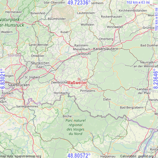
Maßweiler GPS coordinates[2]
49° 16' 0.012" North, 7° 31' 59.988" East
| Map corner | latitude | longitude |
|---|---|---|
| Upper-left | 49.72336°, | 6.83021° |
| Center: | 49.26667°, | 7.53333° |
| Lower-right: | 48.80572°, | 8.23646° |
| Map W x H: | 102×102 km | = 63.4×63.4mi |
| max Lat: | 55.01917° ⇑79.3% North |
| Maßweiler: | 49.26667° |
| min Lat: | ⇓20.7% South 47.40724° |
| min Long | Maßweiler | max Long |
| 5.92978° | 7.53333° | 14.98853° |
| W 13.6%⇐ | ⇒86.4% E |
Elevation
Elevation of Maßweiler is 347 m = 1138 ft, and this is 97.9 m = 321 ft above average elevation for this country.
| Max E: |
1256 m = 4121 ft | 31.4% |
| Maßweiler | 347 m 1138 ft | |
| Avg. | 249.1 m = 817 ft | |
Min E: |
-5 m = -16 ft | 68.6% |
See also: Germany elevation on elevation.city.
Geographical zone
Maßweiler is located in North temperate zone (between Tropic of Cancer and the Arctic Circle). Distance of this North polar circle is 1923.2 km =1195 mi to North.| Distance of | km | miles | from Maßweiler |
|---|---|---|---|
| North Pole | 4529.1 | 2814.3 | to North |
| Arctic Circle | 1923.2 | 1195 | to North |
| Tropic Cancer | 2872 | 1784.6 | to South |
| Equator | 5477.9 | 3403.8 | to South |


Nearby cities:
15 places around Maßweiler: (largest is in red/bold)
• Battweiler
5.2 km =3.2 mi,  284°
284°
• Dellfeld
5.6 km =3.5 mi,  229°
229°
• Herschberg
4.4 km =2.7 mi,  14°
14°
• Höheinöd
5.9 km =3.7 mi,  64°
64°
• Höheischweiler
3.9 km =2.4 mi,  161°
161°
• Höhfröschen
3 km =1.9 mi,  127°
127°
• Nünschweiler
5.2 km =3.2 mi,  201°
201°
• Petersberg
4.4 km =2.7 mi,  146°
146°
• Reifenberg
2.5 km =1.6 mi,  316°
316°
• Rieschweiler-Mühlbach
4.4 km =2.7 mi,  213°
213°
• Saalstadt
5.7 km =3.5 mi, 12°
• Schmitshausen
3.9 km =2.4 mi,  341°
341°
• Thaleischweiler-Fröschen
3.6 km =2.2 mi,  90°
90°
• Wallhalben
5.7 km =3.5 mi,  351°
351°
• Winterbach
6 km =3.7 mi,  312°
312°
Sources, notices
• [Note1] Compared only with cities in Germany existing in our database
• [Src1] Map data: © OpenStreetMap contributors (CC-BY-SA)
• [Src2] Other city data from geonames.org with taken over terms of usage.
• [Src3] Geographical zone / Annual Mean Temperature by Robert A. Rohde @ Wikipedia
