Reichartshausen geodata
Reichartshausen (Baden-Württemberg) is a seat of a fourth-order administrative division; located in Germany in Europe/Berlin (GMT+2) time zone. With population of 1,926 people, there are 5173 cities with bigger population in this country. Compared to other cities in Germany, 77.8% of cities are located further ↑North; 66.1% of cities are located further →East and 50.2% of cities have higher elevation than Reichartshausen. Note1
Administrative division(s):
- Level 1: Baden-Württemberg
- Level 2: Karlsruhe Region
- Level 3: Rhein-Neckar-Kreis
- Level 4: Reichartshausen


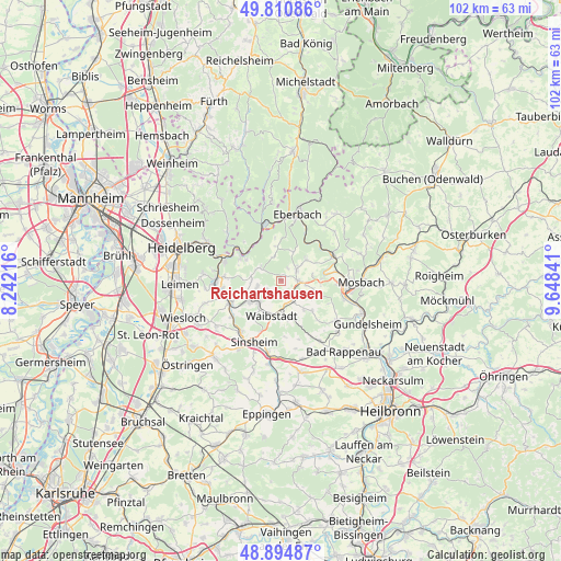
Reichartshausen GPS coordinates[2]
49° 21' 18" North, 8° 56' 43.008" East
| Map corner | latitude | longitude |
|---|---|---|
| Upper-left | 49.81086°, | 8.24216° |
| Center: | 49.355°, | 8.94528° |
| Lower-right: | 48.89487°, | 9.64841° |
| Map W x H: | 101.8×101.8 km | = 63.3×63.3mi |
| max Lat: | 55.01917° ⇑77.8% North |
| Reichartshausen: | 49.355° |
| min Lat: | ⇓22.2% South 47.40724° |
| min Long | Reichartshausen | max Long |
| 5.92978° | 8.94528° | 14.98853° |
| W 33.9%⇐ | ⇒66.1% E |
Elevation
Elevation of Reichartshausen is 224 m = 735 ft, and this is 25.1 m = 82 ft below average elevation for this country.
| Max E: |
1256 m = 4121 ft | 50.2% |
| Avg. | 249.1 m = 817 ft | |
| Reichartshausen | 224 m = 735 ft | |
Min E: |
-5 m = -16 ft | 49.8% |
See also: Germany elevation on elevation.city.
Geographical zone
Reichartshausen is located in North temperate zone (between Tropic of Cancer and the Arctic Circle). Distance of this North polar circle is 1913.4 km =1188.9 mi to North.| Distance of | km | miles | from Reichartshausen |
|---|---|---|---|
| North Pole | 4519.3 | 2808.2 | to North |
| Arctic Circle | 1913.4 | 1188.9 | to North |
| Tropic Cancer | 2881.8 | 1790.7 | to South |
| Equator | 5487.8 | 3410 | to South |


Nearby cities:
15 places around Reichartshausen: (largest is in red/bold)
• Aglasterhausen
3 km =1.9 mi,  85°
85°
• Binau
8.3 km =5.2 mi,  79°
79°
• Epfenbach
3.2 km =2 mi,  237°
237°
• Eschelbronn
7 km =4.3 mi, 235°
• Helmstadt-Bargen
5.9 km =3.7 mi,  140°
140°
• Lobbach
4.7 km =2.9 mi,  298°
298°
• Meckesheim
9.8 km =6.1 mi,  247°
247°
• Neckarbischofsheim
6.7 km =4.2 mi,  168°
168°
• Neckargerach
10.1 km =6.3 mi,  60°
60°
• Neckarsteinach
9.4 km =5.8 mi,  308°
308°
• Neidenstein
6.1 km =3.8 mi,  225°
225°
• Neunkirchen
5.9 km =3.7 mi,  53°
53°
• Spechbach
4.6 km =2.9 mi,  257°
257°
• Waibstadt
7 km =4.3 mi,  196°
196°
• Zwingenberg
9.9 km =6.2 mi,  44°
44°
Sources, notices
• [Note1] Compared only with cities in Germany existing in our database
• [Src1] Map data: © OpenStreetMap contributors (CC-BY-SA)
• [Src2] Other city data from geonames.org with taken over terms of usage.
• [Src3] Geographical zone / Annual Mean Temperature by Robert A. Rohde @ Wikipedia
