Binau geodata
Binau (Baden-Württemberg) is a seat of a fourth-order administrative division; located in Germany in Europe/Berlin (GMT+2) time zone. With population of 1,311 people, there are 6275 cities with bigger population in this country. Compared to other cities in Germany, 77.6% of cities are located further ↑North; 64.7% of cities are located further →East and 57.8% of cities have higher elevation than Binau. Note1
Administrative division(s):
- Level 1: Baden-Württemberg
- Level 2: Karlsruhe Region
- Level 3: Neckar-Odenwald-Kreis
- Level 4: Binau


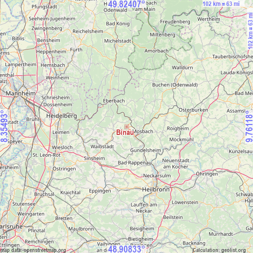
Binau GPS coordinates[2]
49° 22' 5.988" North, 9° 3' 29.016" East
| Map corner | latitude | longitude |
|---|---|---|
| Upper-left | 49.82407°, | 8.35493° |
| Center: | 49.36833°, | 9.05806° |
| Lower-right: | 48.90833°, | 9.76118° |
| Map W x H: | 101.8×101.8 km | = 63.3×63.3mi |
| max Lat: | 55.01917° ⇑77.6% North |
| Binau: | 49.36833° |
| min Lat: | ⇓22.4% South 47.40724° |
| min Long | Binau | max Long |
| 5.92978° | 9.05806° | 14.98853° |
| W 35.3%⇐ | ⇒64.7% E |
Elevation
Elevation of Binau is 169 m = 554 ft, and this is 80.1 m = 263 ft below average elevation for this country.
| Max E: |
1256 m = 4121 ft | 57.8% |
| Avg. | 249.1 m = 817 ft | |
| Binau | 169 m = 554 ft | |
Min E: |
-5 m = -16 ft | 42.2% |
See also: Germany elevation on elevation.city.
Geographical zone
Binau is located in North temperate zone (between Tropic of Cancer and the Arctic Circle). Distance of this North polar circle is 1911.9 km =1188 mi to North.| Distance of | km | miles | from Binau |
|---|---|---|---|
| North Pole | 4517.8 | 2807.2 | to North |
| Arctic Circle | 1911.9 | 1188 | to North |
| Tropic Cancer | 2883.3 | 1791.6 | to South |
| Equator | 5489.2 | 3410.8 | to South |


Nearby cities:
15 places around Binau: (largest is in red/bold)
• Aglasterhausen
5.3 km =3.3 mi,  256°
256°
• Epfenbach
11.4 km =7.1 mi,  253°
253°
• Fahrenbach
9.7 km =6 mi,  43°
43°
• Haßmersheim
10.1 km =6.3 mi,  138°
138°
• Helmstadt-Bargen
7.5 km =4.7 mi,  216°
216°
• Hüffenhardt
8.7 km =5.4 mi,  168°
168°
• Mosbach
6.9 km =4.3 mi,  103°
103°
• Neckarbischofsheim
10.5 km =6.5 mi, 220°
• Neckargerach
3.6 km =2.2 mi,  10°
10°
• Neckarzimmern
7.7 km =4.8 mi, 135°
• Neunkirchen
4 km =2.5 mi,  301°
301°
• Obrigheim
3 km =1.9 mi,  127°
127°
• Reichartshausen
8.3 km =5.2 mi, 259°
• Siegelsbach
11.2 km =7 mi, 168°
• Zwingenberg
5.8 km =3.6 mi,  347°
347°
Sources, notices
• [Note1] Compared only with cities in Germany existing in our database
• [Src1] Map data: © OpenStreetMap contributors (CC-BY-SA)
• [Src2] Other city data from geonames.org with taken over terms of usage.
• [Src3] Geographical zone / Annual Mean Temperature by Robert A. Rohde @ Wikipedia
