Neckarsteinach geodata
Neckarsteinach (Hesse) is a populated place; located in Germany in Europe/Berlin (GMT+2) time zone. With population of 3,923 people, there are 3340 cities with bigger population in this country. Compared to other cities in Germany, 77.1% of cities are located further ↑North; 67.4% of cities are located further →East and 55.4% of cities have higher elevation than Neckarsteinach. Note1
Administrative division(s):
- Level 1: Hesse
- Level 2: Regierungsbezirk Darmstadt
- Level 3: Landkreis Bergstraße
- Level 4: Neckarsteinach


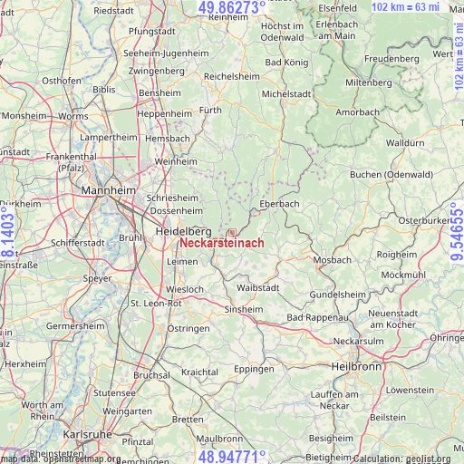
Neckarsteinach GPS coordinates[2]
49° 24' 26.46" North, 8° 50' 36.312" East
| Map corner | latitude | longitude |
|---|---|---|
| Upper-left | 49.86273°, | 8.1403° |
| Center: | 49.40735°, | 8.84342° |
| Lower-right: | 48.94771°, | 9.54655° |
| Map W x H: | 101.7×101.7 km | = 63.2×63.2mi |
| max Lat: | 55.01917° ⇑77.1% North |
| Neckarsteinach: | 49.40735° |
| min Lat: | ⇓22.9% South 47.40724° |
| min Long | Neckarsteinach | max Long |
| 5.92978° | 8.84342° | 14.98853° |
| W 32.6%⇐ | ⇒67.4% E |
Elevation
Elevation of Neckarsteinach is 186 m = 610 ft, and this is 63.1 m = 207 ft below average elevation for this country.
| Max E: |
1256 m = 4121 ft | 55.4% |
| Avg. | 249.1 m = 817 ft | |
| Neckarsteinach | 186 m = 610 ft | |
Min E: |
-5 m = -16 ft | 44.6% |
See also: Germany elevation on elevation.city.
Geographical zone
Neckarsteinach is located in North temperate zone (between Tropic of Cancer and the Arctic Circle). Distance of this North polar circle is 1907.6 km =1185.3 mi to North.| Distance of | km | miles | from Neckarsteinach |
|---|---|---|---|
| North Pole | 4513.5 | 2804.6 | to North |
| Arctic Circle | 1907.6 | 1185.3 | to North |
| Tropic Cancer | 2887.7 | 1794.3 | to South |
| Equator | 5493.6 | 3413.6 | to South |


Nearby cities:
15 places around Neckarsteinach: (largest is in red/bold)
• Bammental
7.3 km =4.5 mi,  219°
219°
• Epfenbach
8.9 km =5.5 mi,  148°
148°
• Gaiberg
8.2 km =5.1 mi,  236°
236°
• Heddesbach
8.2 km =5.1 mi,  352°
352°
• Heiligkreuzsteinach
9.1 km =5.7 mi,  337°
337°
• Hirschhorn
5.7 km =3.5 mi,  41°
41°
• Lobbach
4.9 km =3 mi,  137°
137°
• Mauer
8 km =5 mi,  202°
202°
• Meckesheim
9.7 km =6 mi,  190°
190°
• Neckargemünd
4 km =2.5 mi, 239°
• Reichartshausen
9.4 km =5.8 mi,  128°
128°
• Schönau
4.1 km =2.5 mi,  322°
322°
• Spechbach
7.4 km =4.6 mi,  156°
156°
• Wiesenbach
5.9 km =3.7 mi,  209°
209°
• Wilhelmsfeld
9.6 km =6 mi, 317°
Sources, notices
• [Note1] Compared only with cities in Germany existing in our database
• [Src1] Map data: © OpenStreetMap contributors (CC-BY-SA)
• [Src2] Other city data from geonames.org with taken over terms of usage.
• [Src3] Geographical zone / Annual Mean Temperature by Robert A. Rohde @ Wikipedia
