Looft geodata
Looft (Schleswig-Holstein) is a seat of a fourth-order administrative division; located in Germany in Europe/Berlin (GMT+2) time zone. With population of 392 people, there are 9717 cities with bigger population in this country. Compared to other cities in Germany, 93% of cities are located further ↓South; 57.4% of cities are located further →East and 94.3% of cities have higher elevation than Looft. Note1


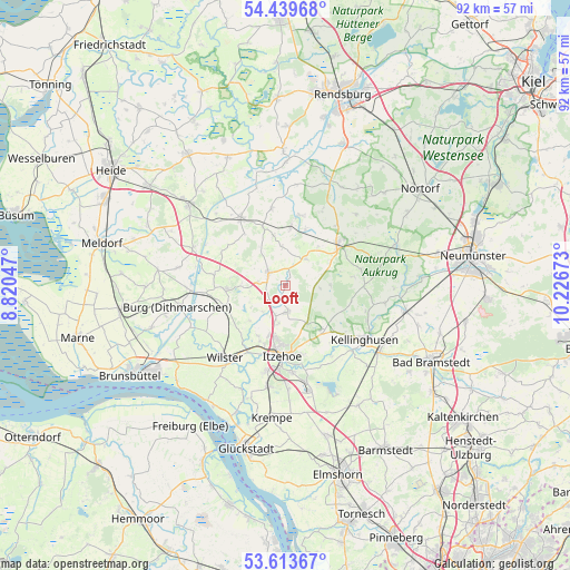
Looft GPS coordinates[2]
54° 1' 43.428" North, 9° 31' 24.96" East
| Map corner | latitude | longitude |
|---|---|---|
| Upper-left | 54.43968°, | 8.82047° |
| Center: | 54.02873°, | 9.5236° |
| Lower-right: | 53.61367°, | 10.22673° |
| Map W x H: | 91.8×91.8 km | = 57×57mi |
| max Lat: | 55.01917° ⇑7% North |
| Looft: | 54.02873° |
| min Lat: | ⇓93% South 47.40724° |
| min Long | Looft | max Long |
| 5.92978° | 9.5236° | 14.98853° |
| W 42.6%⇐ | ⇒57.4% E |
Elevation
Elevation of Looft is 10 m = 33 ft, and this is 239.1 m = 784 ft below average elevation for this country.
| Max E: |
1256 m = 4121 ft | 94.3% |
| Avg. | 249.1 m = 817 ft | |
| Looft | 10 m = 33 ft | |
Min E: |
-5 m = -16 ft | 5.7% |
See also: Germany elevation on elevation.city.
Geographical zone
Looft is located in North temperate zone (between Tropic of Cancer and the Arctic Circle). Distance of this North polar circle is 1393.7 km =866 mi to North.| Distance of | km | miles | from Looft |
|---|---|---|---|
| North Pole | 3999.6 | 2485.2 | to North |
| Arctic Circle | 1393.7 | 866 | to North |
| Tropic Cancer | 3401.5 | 2113.6 | to South |
| Equator | 6007.4 | 3732.8 | to South |


Nearby cities:
15 places around Looft: (largest is in red/bold)
• Agethorst
5.8 km =3.6 mi,  259°
259°
• Christinenthal
2.4 km =1.5 mi,  15°
15°
• Drage
2.8 km =1.7 mi,  185°
185°
• Hadenfeld
4.5 km =2.8 mi,  277°
277°
• Hohenaspe
4.4 km =2.7 mi,  176°
176°
• Kaaks
5.6 km =3.5 mi,  219°
219°
• Kaisborstel
3.2 km =2 mi,  238°
238°
• Mehlbek
6.4 km =4 mi,  245°
245°
• Oldenborstel
4.2 km =2.6 mi,  353°
353°
• Peissen
5.5 km =3.4 mi,  93°
93°
• Puls
6.1 km =3.8 mi,  355°
355°
• Pöschendorf
2.5 km =1.6 mi,  292°
292°
• Reher
5.7 km =3.5 mi,  42°
42°
• Schenefeld
3.5 km =2.2 mi,  311°
311°
• Silzen
6.1 km =3.8 mi, 85°
Sources, notices
• [Note1] Compared only with cities in Germany existing in our database
• [Src1] Map data: © OpenStreetMap contributors (CC-BY-SA)
• [Src2] Other city data from geonames.org with taken over terms of usage.
• [Src3] Geographical zone / Annual Mean Temperature by Robert A. Rohde @ Wikipedia
