Hainfeld geodata
Hainfeld (Rheinland-Pfalz) is a seat of a fourth-order administrative division; located in Germany in Europe/Berlin (GMT+2) time zone. With population of 686 people, there are 8384 cities with bigger population in this country. Compared to other cities in Germany, 79.4% of cities are located further ↑North; 75.4% of cities are located further →East and 55.7% of cities have higher elevation than Hainfeld. Note1
Administrative division(s):
- Level 1: Rheinland-Pfalz
- Level 3: Landkreis Südliche Weinstraße
- Level 4: Hainfeld


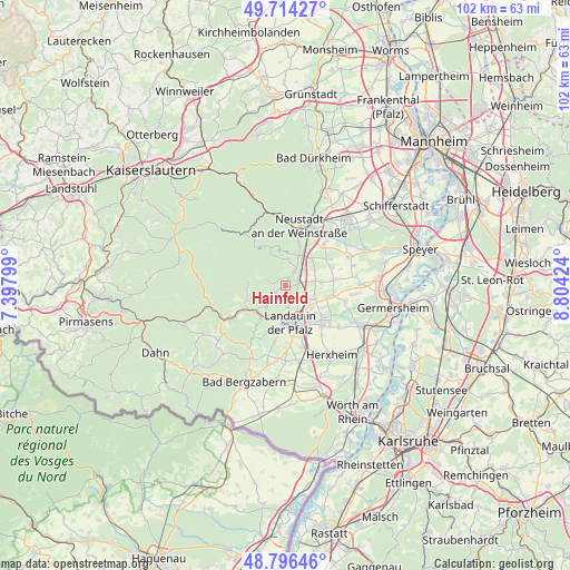
Hainfeld GPS coordinates[2]
49° 15' 27" North, 8° 6' 3.996" East
| Map corner | latitude | longitude |
|---|---|---|
| Upper-left | 49.71427°, | 7.39799° |
| Center: | 49.2575°, | 8.10111° |
| Lower-right: | 48.79646°, | 8.80424° |
| Map W x H: | 102.1×10² km | = 63.4×63.4mi |
| max Lat: | 55.01917° ⇑79.4% North |
| Hainfeld: | 49.2575° |
| min Lat: | ⇓20.6% South 47.40724° |
| min Long | Hainfeld | max Long |
| 5.92978° | 8.10111° | 14.98853° |
| W 24.6%⇐ | ⇒75.4% E |
Elevation
Elevation of Hainfeld is 184 m = 604 ft, and this is 65.1 m = 214 ft below average elevation for this country.
| Max E: |
1256 m = 4121 ft | 55.7% |
| Avg. | 249.1 m = 817 ft | |
| Hainfeld | 184 m = 604 ft | |
Min E: |
-5 m = -16 ft | 44.3% |
See also: Germany elevation on elevation.city.
Geographical zone
Hainfeld is located in North temperate zone (between Tropic of Cancer and the Arctic Circle). Distance of this North polar circle is 1924.3 km =1195.7 mi to North.| Distance of | km | miles | from Hainfeld |
|---|---|---|---|
| North Pole | 4530.1 | 2814.9 | to North |
| Arctic Circle | 1924.3 | 1195.7 | to North |
| Tropic Cancer | 2871 | 1784 | to South |
| Equator | 5476.9 | 3403.2 | to South |


Nearby cities:
15 places around Hainfeld: (largest is in red/bold)
• Burrweiler
2 km =1.2 mi,  236°
236°
• Böchingen
2.4 km =1.5 mi,  193°
193°
• Edenkoben
3.5 km =2.2 mi,  32°
32°
• Edesheim
2.5 km =1.6 mi,  75°
75°
• Flemlingen
1.7 km =1.1 mi,  195°
195°
• Frankweiler
4.5 km =2.8 mi,  223°
223°
• Gleisweiler
2.9 km =1.8 mi,  233°
233°
• Großfischlingen
5.6 km =3.5 mi, 76°
• Knöringen
3.8 km =2.4 mi,  124°
124°
• Maikammer
5.8 km =3.6 mi,  22°
22°
• Rhodt unter Rietburg
1.4 km =0.9 mi, 19°
• Roschbach
1.8 km =1.1 mi,  134°
134°
• Sankt Martin
4.8 km =3 mi,  3°
3°
• Walsheim
2.9 km =1.8 mi,  140°
140°
• Weyher
1.6 km =1 mi,  313°
313°
Sources, notices
• [Note1] Compared only with cities in Germany existing in our database
• [Src1] Map data: © OpenStreetMap contributors (CC-BY-SA)
• [Src2] Other city data from geonames.org with taken over terms of usage.
• [Src3] Geographical zone / Annual Mean Temperature by Robert A. Rohde @ Wikipedia
