Quedlinburg geodata
Quedlinburg (Saxony-Anhalt) is a populated place; located in Germany in Europe/Berlin (GMT+2) time zone. With population of 22,814 people, there are 654 cities with bigger population in this country. Compared to other cities in Germany, 69.8% of cities are located further ↓South; 69.2% of cities are located further ←West and 64.6% of cities have higher elevation than Quedlinburg. Note1


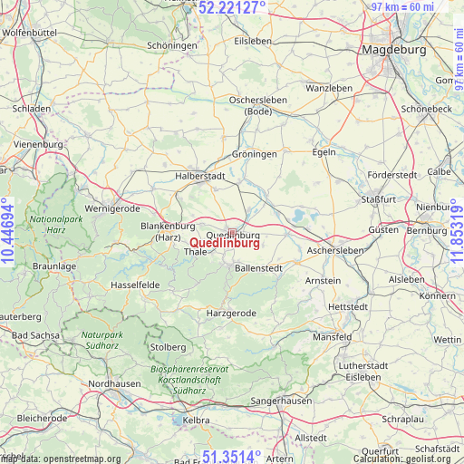
Quedlinburg GPS coordinates[2]
51° 47' 18.348" North, 11° 9' 0.216" East
| Map corner | latitude | longitude |
|---|---|---|
| Upper-left | 52.22127°, | 10.44694° |
| Center: | 51.78843°, | 11.15006° |
| Lower-right: | 51.3514°, | 11.85319° |
| Map W x H: | 96.7×96.7 km | = 60.1×60.1mi |
| max Lat: | 55.01917° ⇑30.2% North |
| Quedlinburg: | 51.78843° |
| min Lat: | ⇓69.8% South 47.40724° |
| min Long | Quedlinburg | max Long |
| 5.92978° | 11.15006° | 14.98853° |
| W 69.2%⇐ | ⇒30.8% E |
Elevation
Elevation of Quedlinburg is 123 m = 404 ft, and this is 126.1 m = 414 ft below average elevation for this country.
| Max E: |
1256 m = 4121 ft | 64.6% |
| Avg. | 249.1 m = 817 ft | |
| Quedlinburg | 123 m = 404 ft | |
Min E: |
-5 m = -16 ft | 35.4% |
See also: Germany elevation on elevation.city.
Geographical zone
Quedlinburg is located in North temperate zone (between Tropic of Cancer and the Arctic Circle). Distance of this North polar circle is 1642.8 km =1020.8 mi to North.| Distance of | km | miles | from Quedlinburg |
|---|---|---|---|
| North Pole | 4248.7 | 2640 | to North |
| Arctic Circle | 1642.8 | 1020.8 | to North |
| Tropic Cancer | 3152.4 | 1958.8 | to South |
| Equator | 5758.3 | 3578 | to South |


Nearby cities:
15 places around Quedlinburg: (largest is in red/bold)
• Bad Suderode
6.5 km =4 mi,  200°
200°
• Ballenstedt
9.6 km =6 mi,  143°
143°
• Ditfurt
6.1 km =3.8 mi,  34°
34°
• Gatersleben
10.1 km =6.3 mi,  68°
68°
• Gernrode
7 km =4.3 mi,  186°
186°
• Harsleben
9.4 km =5.8 mi,  338°
338°
• Hausneindorf
10.2 km =6.3 mi,  55°
55°
• Neinstedt
6.1 km =3.8 mi,  224°
224°
• Rieder
6.2 km =3.9 mi,  169°
169°
• Stecklenberg
7.5 km =4.7 mi, 215°
• Thale
8.7 km =5.4 mi,  239°
239°
• Timmenrode
10.1 km =6.3 mi,  258°
258°
• Weddersleben
5.1 km =3.2 mi, 240°
• Wedderstedt
8.6 km =5.3 mi,  48°
48°
• Westerhausen
6.7 km =4.2 mi,  286°
286°
Sources, notices
• [Note1] Compared only with cities in Germany existing in our database
• [Src1] Map data: © OpenStreetMap contributors (CC-BY-SA)
• [Src2] Other city data from geonames.org with taken over terms of usage.
• [Src3] Geographical zone / Annual Mean Temperature by Robert A. Rohde @ Wikipedia
