Harsleben geodata
Harsleben (Saxony-Anhalt) is a seat of a fourth-order administrative division; located in Germany in Europe/Berlin (GMT+2) time zone. With population of 2,395 people, there are 4564 cities with bigger population in this country. Compared to other cities in Germany, 70.7% of cities are located further ↓South; 68.4% of cities are located further ←West and 65.6% of cities have higher elevation than Harsleben. Note1


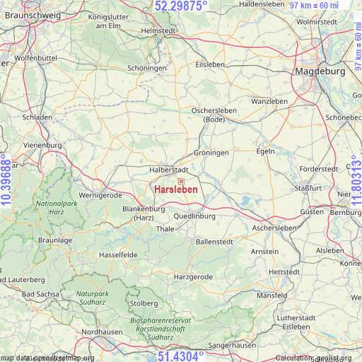
Harsleben GPS coordinates[2]
51° 52' 0.012" North, 11° 6' 0" East
| Map corner | latitude | longitude |
|---|---|---|
| Upper-left | 52.29875°, | 10.39688° |
| Center: | 51.86667°, | 11.1° |
| Lower-right: | 51.4304°, | 11.80313° |
| Map W x H: | 96.6×96.6 km | = 60×60mi |
| max Lat: | 55.01917° ⇑29.3% North |
| Harsleben: | 51.86667° |
| min Lat: | ⇓70.7% South 47.40724° |
| min Long | Harsleben | max Long |
| 5.92978° | 11.1° | 14.98853° |
| W 68.4%⇐ | ⇒31.6% E |
Elevation
Elevation of Harsleben is 117 m = 384 ft, and this is 132.1 m = 433 ft below average elevation for this country.
| Max E: |
1256 m = 4121 ft | 65.6% |
| Avg. | 249.1 m = 817 ft | |
| Harsleben | 117 m = 384 ft | |
Min E: |
-5 m = -16 ft | 34.4% |
See also: Germany elevation on elevation.city.
Geographical zone
Harsleben is located in North temperate zone (between Tropic of Cancer and the Arctic Circle). Distance of this North polar circle is 1634.1 km =1015.4 mi to North.| Distance of | km | miles | from Harsleben |
|---|---|---|---|
| North Pole | 4240 | 2634.6 | to North |
| Arctic Circle | 1634.1 | 1015.4 | to North |
| Tropic Cancer | 3161.1 | 1964.2 | to South |
| Equator | 5767 | 3583.4 | to South |


Nearby cities:
15 places around Harsleben: (largest is in red/bold)
• Ditfurt
7.8 km =4.8 mi,  118°
118°
• Groß Quenstedt
7.5 km =4.7 mi,  8°
8°
• Gröningen
11.2 km =7 mi,  45°
45°
• Halberstadt
4.4 km =2.7 mi,  316°
316°
• Hausneindorf
12.2 km =7.6 mi,  104°
104°
• Hedersleben
10.3 km =6.4 mi,  94°
94°
• Langenstein
7.8 km =4.8 mi,  260°
260°
• Quedlinburg
9.4 km =5.8 mi,  158°
158°
• Sargstedt
11.3 km =7 mi, 316°
• Schwanebeck
11.4 km =7.1 mi, 8°
• Ströbeck
11.9 km =7.4 mi,  296°
296°
• Weddersleben
11.3 km =7 mi,  185°
185°
• Wedderstedt
10.3 km =6.4 mi,  106°
106°
• Wegeleben
5.4 km =3.4 mi,  69°
69°
• Westerhausen
7.4 km =4.6 mi,  203°
203°
Sources, notices
• [Note1] Compared only with cities in Germany existing in our database
• [Src1] Map data: © OpenStreetMap contributors (CC-BY-SA)
• [Src2] Other city data from geonames.org with taken over terms of usage.
• [Src3] Geographical zone / Annual Mean Temperature by Robert A. Rohde @ Wikipedia
