Putlitz geodata
Putlitz (Brandenburg) is a populated place; located in Germany in Europe/Berlin (GMT+2) time zone. With population of 3,100 people, there are 3915 cities with bigger population in this country. Compared to other cities in Germany, 83.3% of cities are located further ↓South; 82.3% of cities are located further ←West and 76.7% of cities have higher elevation than Putlitz. Note1


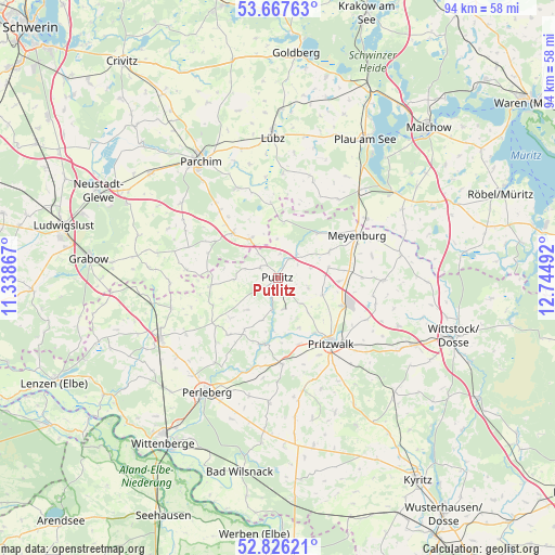
Putlitz GPS coordinates[2]
53° 14' 56.364" North, 12° 2' 30.444" East
| Map corner | latitude | longitude |
|---|---|---|
| Upper-left | 53.66763°, | 11.33867° |
| Center: | 53.24899°, | 12.04179° |
| Lower-right: | 52.82621°, | 12.74492° |
| Map W x H: | 93.6×93.6 km | = 58.2×58.2mi |
| max Lat: | 55.01917° ⇑16.7% North |
| Putlitz: | 53.24899° |
| min Lat: | ⇓83.3% South 47.40724° |
| min Long | Putlitz | max Long |
| 5.92978° | 12.04179° | 14.98853° |
| W 82.3%⇐ | ⇒17.7% E |
Elevation
Elevation of Putlitz is 57 m = 187 ft, and this is 192.1 m = 630 ft below average elevation for this country.
| Max E: |
1256 m = 4121 ft | 76.7% |
| Avg. | 249.1 m = 817 ft | |
| Putlitz | 57 m = 187 ft | |
Min E: |
-5 m = -16 ft | 23.3% |
See also: Germany elevation on elevation.city.
Geographical zone
Putlitz is located in North temperate zone (between Tropic of Cancer and the Arctic Circle). Distance of this North polar circle is 1480.4 km =919.9 mi to North.| Distance of | km | miles | from Putlitz |
|---|---|---|---|
| North Pole | 4086.3 | 2539.1 | to North |
| Arctic Circle | 1480.4 | 919.9 | to North |
| Tropic Cancer | 3314.8 | 2059.7 | to South |
| Equator | 5920.7 | 3679 | to South |


Nearby cities:
15 places around Putlitz: (largest is in red/bold)
• Berge
11.8 km =7.3 mi,  261°
261°
• Ganzlin
20.3 km =12.6 mi,  42°
42°
• Gerdshagen
10.4 km =6.5 mi,  92°
92°
• Groß Pankow
14.4 km =8.9 mi,  177°
177°
• Karstädt
22.2 km =13.8 mi,  244°
244°
• Löcknitz
17.8 km =11.1 mi,  283°
283°
• Marnitz
10.6 km =6.6 mi,  315°
315°
• Neuburg
19.4 km =12.1 mi,  334°
334°
• Perleberg
22.8 km =14.2 mi,  212°
212°
• Pirow
10.1 km =6.3 mi,  249°
249°
• Pritzwalk
14.1 km =8.8 mi,  141°
141°
• Rom
22.6 km =14 mi,  344°
344°
• Siggelkow
16.9 km =10.5 mi, 335°
• Triglitz
5.3 km =3.3 mi,  132°
132°
• Ziegendorf
16 km =9.9 mi,  289°
289°
Sources, notices
• [Note1] Compared only with cities in Germany existing in our database
• [Src1] Map data: © OpenStreetMap contributors (CC-BY-SA)
• [Src2] Other city data from geonames.org with taken over terms of usage.
• [Src3] Geographical zone / Annual Mean Temperature by Robert A. Rohde @ Wikipedia
