Prisannewitz geodata
Prisannewitz (Mecklenburg-Vorpommern) is a populated place; located in Germany in Europe/Berlin (GMT+2) time zone. With population of 647 people, there are 8569 cities with bigger population in this country. Compared to other cities in Germany, 92.5% of cities are located further ↓South; 84.9% of cities are located further ←West and 83.7% of cities have higher elevation than Prisannewitz. Note1
Administrative division(s):
- Level 1: Mecklenburg-Vorpommern
- Level 3: Landkreis Rostock
- Level 4: Dummerstorf


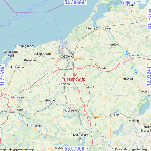
Prisannewitz GPS coordinates[2]
53° 59' 8.016" North, 12° 13' 9.408" East
| Map corner | latitude | longitude |
|---|---|---|
| Upper-left | 54.39694°, | 11.51616° |
| Center: | 53.98556°, | 12.21928° |
| Lower-right: | 53.57008°, | 12.92241° |
| Map W x H: | 91.9×91.9 km | = 57.1×57.1mi |
| max Lat: | 55.01917° ⇑7.5% North |
| Prisannewitz: | 53.98556° |
| min Lat: | ⇓92.5% South 47.40724° |
| min Long | Prisannewitz | max Long |
| 5.92978° | 12.21928° | 14.98853° |
| W 84.9%⇐ | ⇒15.1% E |
Elevation
Elevation of Prisannewitz is 38 m = 125 ft, and this is 211.1 m = 693 ft below average elevation for this country.
| Max E: |
1256 m = 4121 ft | 83.7% |
| Avg. | 249.1 m = 817 ft | |
| Prisannewitz | 38 m = 125 ft | |
Min E: |
-5 m = -16 ft | 16.3% |
See also: Germany elevation on elevation.city.
Geographical zone
Prisannewitz is located in North temperate zone (between Tropic of Cancer and the Arctic Circle). Distance of this North polar circle is 1398.5 km =869 mi to North.| Distance of | km | miles | from Prisannewitz |
|---|---|---|---|
| North Pole | 4004.4 | 2488.2 | to North |
| Arctic Circle | 1398.5 | 869 | to North |
| Tropic Cancer | 3396.7 | 2110.6 | to South |
| Equator | 6002.6 | 3729.8 | to South |


Nearby cities:
15 places around Prisannewitz: (largest is in red/bold)
• Broderstorf
11 km =6.8 mi,  15°
15°
• Cammin
9.2 km =5.7 mi,  86°
86°
• Damm
5.1 km =3.2 mi,  301°
301°
• Dolgen
4.5 km =2.8 mi,  141°
141°
• Dummerstorf
3.3 km =2.1 mi,  10°
10°
• Hohen Sprenz
8.4 km =5.2 mi,  190°
190°
• Kavelstorf
2.9 km =1.8 mi,  320°
320°
• Laage
10.7 km =6.6 mi,  128°
128°
• Lieblingshof
8.7 km =5.4 mi,  55°
55°
• Mistorf
12.3 km =7.6 mi,  203°
203°
• Papendorf
7.9 km =4.9 mi,  314°
314°
• Roggentin
9.5 km =5.9 mi,  354°
354°
• Schwaan
8.9 km =5.5 mi,  235°
235°
• Wiendorf
6.3 km =3.9 mi,  225°
225°
• Ziesendorf
11.8 km =7.3 mi,  274°
274°
Sources, notices
• [Note1] Compared only with cities in Germany existing in our database
• [Src1] Map data: © OpenStreetMap contributors (CC-BY-SA)
• [Src2] Other city data from geonames.org with taken over terms of usage.
• [Src3] Geographical zone / Annual Mean Temperature by Robert A. Rohde @ Wikipedia
