Lieblingshof geodata
Lieblingshof (Mecklenburg-Vorpommern) is a populated place; located in Germany in Europe/Berlin (GMT+2) time zone. With population of 710 people, there are 8272 cities with bigger population in this country. Compared to other cities in Germany, 93% of cities are located further ↓South; 86.1% of cities are located further ←West and 86.6% of cities have higher elevation than Lieblingshof. Note1
Administrative division(s):
- Level 1: Mecklenburg-Vorpommern
- Level 3: Landkreis Rostock
- Level 4: Dummerstorf


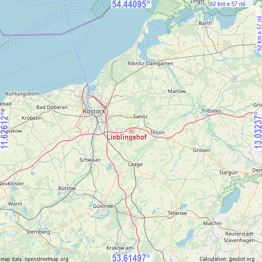
Lieblingshof GPS coordinates[2]
54° 1' 48.036" North, 12° 19' 45.264" East
| Map corner | latitude | longitude |
|---|---|---|
| Upper-left | 54.44095°, | 11.62612° |
| Center: | 54.03001°, | 12.32924° |
| Lower-right: | 53.61497°, | 13.03237° |
| Map W x H: | 91.8×91.8 km | = 57×57mi |
| max Lat: | 55.01917° ⇑7% North |
| Lieblingshof: | 54.03001° |
| min Lat: | ⇓93% South 47.40724° |
| min Long | Lieblingshof | max Long |
| 5.92978° | 12.32924° | 14.98853° |
| W 86.1%⇐ | ⇒13.9% E |
Elevation
Elevation of Lieblingshof is 31 m = 102 ft, and this is 218.1 m = 716 ft below average elevation for this country.
| Max E: |
1256 m = 4121 ft | 86.6% |
| Avg. | 249.1 m = 817 ft | |
| Lieblingshof | 31 m = 102 ft | |
Min E: |
-5 m = -16 ft | 13.4% |
See also: Germany elevation on elevation.city.
Geographical zone
Lieblingshof is located in North temperate zone (between Tropic of Cancer and the Arctic Circle). Distance of this North polar circle is 1393.6 km =865.9 mi to North.| Distance of | km | miles | from Lieblingshof |
|---|---|---|---|
| North Pole | 3999.5 | 2485.2 | to North |
| Arctic Circle | 1393.6 | 865.9 | to North |
| Tropic Cancer | 3401.7 | 2113.7 | to South |
| Equator | 6007.6 | 3732.9 | to South |


Nearby cities:
15 places around Lieblingshof: (largest is in red/bold)
• Bentwisch
12.5 km =7.8 mi,  319°
319°
• Broderstorf
7.1 km =4.4 mi, 322°
• Cammin
4.8 km =3 mi,  155°
155°
• Damm
11.8 km =7.3 mi,  258°
258°
• Dolgen
9.5 km =5.9 mi,  207°
207°
• Dummerstorf
6.8 km =4.2 mi, 255°
• Kavelstorf
9.4 km =5.8 mi,  253°
253°
• Klein Kussewitz
12.8 km =8 mi,  333°
333°
• Laage
11.7 km =7.3 mi,  174°
174°
• Prisannewitz
8.7 km =5.4 mi,  235°
235°
• Roggentin
9.3 km =5.8 mi,  299°
299°
• Selpin
11.7 km =7.3 mi,  111°
111°
• Tessin
8.9 km =5.5 mi,  91°
91°
• Thulendorf
7.4 km =4.6 mi,  346°
346°
• Wardow
12.2 km =7.6 mi,  154°
154°
Sources, notices
• [Note1] Compared only with cities in Germany existing in our database
• [Src1] Map data: © OpenStreetMap contributors (CC-BY-SA)
• [Src2] Other city data from geonames.org with taken over terms of usage.
• [Src3] Geographical zone / Annual Mean Temperature by Robert A. Rohde @ Wikipedia
