Pohl geodata
Pohl (Rheinland-Pfalz) is a seat of a fourth-order administrative division; located in Germany in Europe/Berlin (GMT+2) time zone. With population of 377 people, there are 9767 cities with bigger population in this country. Compared to other cities in Germany, 57.9% of cities are located further ↑North; 79.7% of cities are located further →East and 66.2% of cities have lower elevation than Pohl. Note1


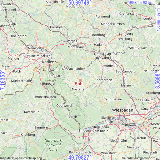
Pohl GPS coordinates[2]
50° 15' 0" North, 7° 52' 0.012" East
| Map corner | latitude | longitude |
|---|---|---|
| Upper-left | 50.69749°, | 7.16355° |
| Center: | 50.25°, | 7.86667° |
| Lower-right: | 49.79827°, | 8.5698° |
| Map W x H: | 100×100 km | = 62.1×62.1mi |
| max Lat: | 55.01917° ⇑57.9% North |
| Pohl: | 50.25° |
| min Lat: | ⇓42.1% South 47.40724° |
| min Long | Pohl | max Long |
| 5.92978° | 7.86667° | 14.98853° |
| W 20.3%⇐ | ⇒79.7% E |
Elevation
Elevation of Pohl is 330 m = 1083 ft, and this is 80.9 m = 265 ft above average elevation for this country.
| Max E: |
1256 m = 4121 ft | 33.8% |
| Pohl | 330 m 1083 ft | |
| Avg. | 249.1 m = 817 ft | |
Min E: |
-5 m = -16 ft | 66.2% |
See also: Germany elevation on elevation.city.
Geographical zone
Pohl is located in North temperate zone (between Tropic of Cancer and the Arctic Circle). Distance of this North polar circle is 1813.9 km =1127.1 mi to North.| Distance of | km | miles | from Pohl |
|---|---|---|---|
| North Pole | 4419.8 | 2746.3 | to North |
| Arctic Circle | 1813.9 | 1127.1 | to North |
| Tropic Cancer | 2981.4 | 1852.6 | to South |
| Equator | 5587.3 | 3471.8 | to South |


Nearby cities:
15 places around Pohl: (largest is in red/bold)
• Attenhausen
4.7 km =2.9 mi,  7°
7°
• Berg
4 km =2.5 mi,  276°
276°
• Bettendorf
1.9 km =1.2 mi,  175°
175°
• Geisig
5.4 km =3.4 mi,  274°
274°
• Herold
5.5 km =3.4 mi,  56°
56°
• Holzhausen an der Haide
4.6 km =2.9 mi,  138°
138°
• Hunzel
2.1 km =1.3 mi, 267°
• Lollschied
0.7 km =0.4 mi, 13°
• Marienfels
3.9 km =2.4 mi,  254°
254°
• Miehlen
3.7 km =2.3 mi,  222°
222°
• Niedertiefenbach
2.2 km =1.4 mi,  74°
74°
• Obertiefenbach
1.9 km =1.2 mi,  118°
118°
• Rettert
5.5 km =3.4 mi,  112°
112°
• Roth
2.8 km =1.7 mi,  48°
48°
• Singhofen
3.6 km =2.2 mi,  318°
318°
Sources, notices
• [Note1] Compared only with cities in Germany existing in our database
• [Src1] Map data: © OpenStreetMap contributors (CC-BY-SA)
• [Src2] Other city data from geonames.org with taken over terms of usage.
• [Src3] Geographical zone / Annual Mean Temperature by Robert A. Rohde @ Wikipedia
