Berg geodata
Berg (Rheinland-Pfalz) is a seat of a fourth-order administrative division; located in Germany in Europe/Berlin (GMT+2) time zone. With population of 252 people, there are 10253 cities with bigger population in this country. Compared to other cities in Germany, 57.7% of cities are located further ↑North; 80.8% of cities are located further →East and 59.7% of cities have lower elevation than Berg. Note1


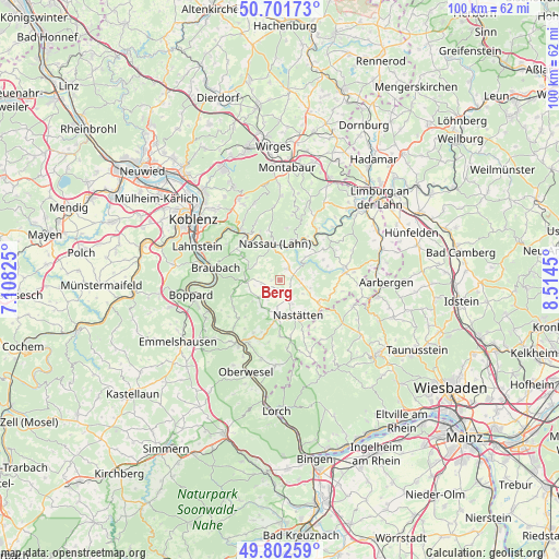
Berg GPS coordinates[2]
50° 15' 15.408" North, 7° 48' 40.932" East
| Map corner | latitude | longitude |
|---|---|---|
| Upper-left | 50.70173°, | 7.10825° |
| Center: | 50.25428°, | 7.81137° |
| Lower-right: | 49.80259°, | 8.5145° |
| Map W x H: | 100×100 km | = 62.1×62.1mi |
| max Lat: | 55.01917° ⇑57.7% North |
| Berg: | 50.25428° |
| min Lat: | ⇓42.3% South 47.40724° |
| min Long | Berg | max Long |
| 5.92978° | 7.81137° | 14.98853° |
| W 19.2%⇐ | ⇒80.8% E |
Elevation
Elevation of Berg is 288 m = 945 ft, and this is 38.9 m = 128 ft above average elevation for this country.
| Max E: |
1256 m = 4121 ft | 40.3% |
| Berg | 288 m 945 ft | |
| Avg. | 249.1 m = 817 ft | |
Min E: |
-5 m = -16 ft | 59.7% |
See also: Germany elevation on elevation.city.
Geographical zone
Berg is located in North temperate zone (between Tropic of Cancer and the Arctic Circle). Distance of this North polar circle is 1813.4 km =1126.8 mi to North.| Distance of | km | miles | from Berg |
|---|---|---|---|
| North Pole | 4419.3 | 2746 | to North |
| Arctic Circle | 1813.4 | 1126.8 | to North |
| Tropic Cancer | 2981.8 | 1852.8 | to South |
| Equator | 5587.8 | 3472.1 | to South |


Nearby cities:
15 places around Berg: (largest is in red/bold)
• Dessighofen
2.8 km =1.7 mi,  278°
278°
• Dornholzhausen
2.4 km =1.5 mi,  319°
319°
• Ehr
2.6 km =1.6 mi,  226°
226°
• Geisig
1.5 km =0.9 mi,  267°
267°
• Hainau
4.1 km =2.5 mi,  210°
210°
• Hunzel
1.9 km =1.2 mi,  107°
107°
• Kehlbach
3.8 km =2.4 mi, 278°
• Lollschied
4.1 km =2.5 mi,  86°
86°
• Marienfels
1.5 km =0.9 mi,  175°
175°
• Miehlen
3.5 km =2.2 mi,  155°
155°
• Niederbachheim
3.3 km =2.1 mi,  258°
258°
• Oberbachheim
4.6 km =2.9 mi, 258°
• Oberwies
4.4 km =2.7 mi,  330°
330°
• Pohl
4 km =2.5 mi,  96°
96°
• Singhofen
2.7 km =1.7 mi,  34°
34°
Sources, notices
• [Note1] Compared only with cities in Germany existing in our database
• [Src1] Map data: © OpenStreetMap contributors (CC-BY-SA)
• [Src2] Other city data from geonames.org with taken over terms of usage.
• [Src3] Geographical zone / Annual Mean Temperature by Robert A. Rohde @ Wikipedia
