Podelzig geodata
Podelzig (Brandenburg) is a seat of a fourth-order administrative division; located in Germany in Europe/Berlin (GMT+2) time zone. With population of 1,015 people, there are 7131 cities with bigger population in this country. Compared to other cities in Germany, 77.1% of cities are located further ↓South; 99.4% of cities are located further ←West and 79.2% of cities have higher elevation than Podelzig. Note1
Administrative division(s):
- Level 1: Brandenburg
- Level 3: Landkreis Märkisch-Oderland
- Level 4: Podelzig


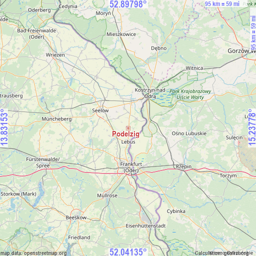
Podelzig GPS coordinates[2]
52° 28' 18.3" North, 14° 32' 4.74" East
| Map corner | latitude | longitude |
|---|---|---|
| Upper-left | 52.89798°, | 13.83153° |
| Center: | 52.47175°, | 14.53465° |
| Lower-right: | 52.04135°, | 15.23778° |
| Map W x H: | 95.2×95.2 km | = 59.2×59.2mi |
| max Lat: | 55.01917° ⇑22.9% North |
| Podelzig: | 52.47175° |
| min Lat: | ⇓77.1% South 47.40724° |
| min Long | Podelzig | max Long |
| 5.92978° | 14.53465° | 14.98853° |
| W 99.4%⇐ | ⇒0.59999999999999% E |
Elevation
Elevation of Podelzig is 49 m = 161 ft, and this is 200.1 m = 656 ft below average elevation for this country.
| Max E: |
1256 m = 4121 ft | 79.2% |
| Avg. | 249.1 m = 817 ft | |
| Podelzig | 49 m = 161 ft | |
Min E: |
-5 m = -16 ft | 20.8% |
See also: Germany elevation on elevation.city.
Geographical zone
Podelzig is located in North temperate zone (between Tropic of Cancer and the Arctic Circle). Distance of this North polar circle is 1566.9 km =973.6 mi to North.| Distance of | km | miles | from Podelzig |
|---|---|---|---|
| North Pole | 4172.8 | 2592.9 | to North |
| Arctic Circle | 1566.9 | 973.6 | to North |
| Tropic Cancer | 3228.4 | 2006 | to South |
| Equator | 5834.3 | 3625.3 | to South |


Nearby cities:
15 places around Podelzig: (largest is in red/bold)
• Alt Tucheband
7.4 km =4.6 mi,  348°
348°
• Briesen
22.5 km =14 mi,  230°
230°
• Falkenhagen
15.4 km =9.6 mi,  253°
253°
• Frankfurt (Oder)
13.9 km =8.6 mi,  175°
175°
• Golzow
11.7 km =7.3 mi, 346°
• Gorgast
10.8 km =6.7 mi,  4°
4°
• Jacobsdorf
19.8 km =12.3 mi,  219°
219°
• Kietz
11.6 km =7.2 mi,  24°
24°
• Lebus
5 km =3.1 mi, 181°
• Lietzen
13.2 km =8.2 mi,  269°
269°
• Manschnow
8.8 km =5.5 mi,  8°
8°
• Reitwein
4.5 km =2.8 mi,  44°
44°
• Seelow
12.5 km =7.8 mi,  303°
303°
• Treplin
12.1 km =7.5 mi, 228°
• Zechin
16.2 km =10.1 mi,  339°
339°
Sources, notices
• [Note1] Compared only with cities in Germany existing in our database
• [Src1] Map data: © OpenStreetMap contributors (CC-BY-SA)
• [Src2] Other city data from geonames.org with taken over terms of usage.
• [Src3] Geographical zone / Annual Mean Temperature by Robert A. Rohde @ Wikipedia
