Manschnow geodata
Manschnow (Brandenburg) is a populated place; located in Germany in Europe/Berlin (GMT+2) time zone. With population of 1,200 people, there are 6562 cities with bigger population in this country. Compared to other cities in Germany, 78% of cities are located further ↓South; 99.4% of cities are located further ←West and 93.5% of cities have higher elevation than Manschnow. Note1
Administrative division(s):
- Level 1: Brandenburg
- Level 3: Landkreis Märkisch-Oderland
- Level 4: Küstriner Vorland


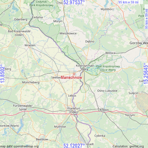
Manschnow GPS coordinates[2]
52° 32' 59.64" North, 14° 33' 11.952" East
| Map corner | latitude | longitude |
|---|---|---|
| Upper-left | 52.97537°, | 13.8502° |
| Center: | 52.5499°, | 14.55332° |
| Lower-right: | 52.12027°, | 15.25645° |
| Map W x H: | 95.1×95.1 km | = 59.1×59.1mi |
| max Lat: | 55.01917° ⇑22% North |
| Manschnow: | 52.5499° |
| min Lat: | ⇓78% South 47.40724° |
| min Long | Manschnow | max Long |
| 5.92978° | 14.55332° | 14.98853° |
| W 99.4%⇐ | ⇒0.59999999999999% E |
Elevation
Elevation of Manschnow is 12 m = 39 ft, and this is 237.1 m = 778 ft below average elevation for this country.
| Max E: |
1256 m = 4121 ft | 93.5% |
| Avg. | 249.1 m = 817 ft | |
| Manschnow | 12 m = 39 ft | |
Min E: |
-5 m = -16 ft | 6.5% |
See also: Germany elevation on elevation.city.
Geographical zone
Manschnow is located in North temperate zone (between Tropic of Cancer and the Arctic Circle). Distance of this North polar circle is 1558.2 km =968.2 mi to North.| Distance of | km | miles | from Manschnow |
|---|---|---|---|
| North Pole | 4164.1 | 2587.5 | to North |
| Arctic Circle | 1558.2 | 968.2 | to North |
| Tropic Cancer | 3237.1 | 2011.4 | to South |
| Equator | 5843 | 3630.7 | to South |


Nearby cities:
15 places around Manschnow: (largest is in red/bold)
• Alt Tucheband
3.1 km =1.9 mi,  243°
243°
• Falkenhagen
20.6 km =12.8 mi,  231°
231°
• Frankfurt (Oder)
22.5 km =14 mi,  180°
180°
• Golzow
4.9 km =3 mi,  303°
303°
• Gorgast
2.1 km =1.3 mi,  350°
350°
• Kietz
4 km =2.5 mi,  62°
62°
• Lebus
13.7 km =8.5 mi,  185°
185°
• Letschin
16.7 km =10.4 mi,  308°
308°
• Lietzen
17 km =10.6 mi, 238°
• Neuhardenberg
21.9 km =13.6 mi,  283°
283°
• Podelzig
8.8 km =5.5 mi, 188°
• Reitwein
5.8 km =3.6 mi,  160°
160°
• Seelow
11.8 km =7.3 mi,  261°
261°
• Treplin
19.6 km =12.2 mi,  211°
211°
• Zechin
9.4 km =5.8 mi, 313°
Sources, notices
• [Note1] Compared only with cities in Germany existing in our database
• [Src1] Map data: © OpenStreetMap contributors (CC-BY-SA)
• [Src2] Other city data from geonames.org with taken over terms of usage.
• [Src3] Geographical zone / Annual Mean Temperature by Robert A. Rohde @ Wikipedia
