Petershausen geodata
Petershausen (Bavaria) is a seat of a fourth-order administrative division; located in Germany in Europe/Berlin (GMT+2) time zone. With population of 5,965 people, there are 2470 cities with bigger population in this country. Compared to other cities in Germany, 90.1% of cities are located further ↑North; 73.9% of cities are located further ←West and 84.3% of cities have lower elevation than Petershausen. Note1
Administrative division(s):
- Level 1: Bavaria
- Level 2: Upper Bavaria
- Level 3: Landkreis Dachau
- Level 4: Petershausen


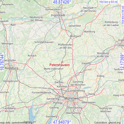
Petershausen GPS coordinates[2]
48° 24' 34.812" North, 11° 28' 14.016" East
| Map corner | latitude | longitude |
|---|---|---|
| Upper-left | 48.87426°, | 10.76744° |
| Center: | 48.40967°, | 11.47056° |
| Lower-right: | 47.94079°, | 12.17369° |
| Map W x H: | 103.8×103.8 km | = 64.5×64.5mi |
| max Lat: | 55.01917° ⇑90.1% North |
| Petershausen: | 48.40967° |
| min Lat: | ⇓9.9% South 47.40724° |
| min Long | Petershausen | max Long |
| 5.92978° | 11.47056° | 14.98853° |
| W 73.9%⇐ | ⇒26.1% E |
Elevation
Elevation of Petershausen is 463 m = 1519 ft, and this is 213.9 m = 702 ft above average elevation for this country.
| Max E: |
1256 m = 4121 ft | 15.7% |
| Petershausen | 463 m 1519 ft | |
| Avg. | 249.1 m = 817 ft | |
Min E: |
-5 m = -16 ft | 84.3% |
See also: Germany elevation on elevation.city.
Geographical zone
Petershausen is located in North temperate zone (between Tropic of Cancer and the Arctic Circle). Distance of this North polar circle is 2018.5 km =1254.2 mi to North.| Distance of | km | miles | from Petershausen |
|---|---|---|---|
| North Pole | 4624.4 | 2873.5 | to North |
| Arctic Circle | 2018.5 | 1254.2 | to North |
| Tropic Cancer | 2776.7 | 1725.4 | to South |
| Equator | 5382.7 | 3344.7 | to South |


Nearby cities:
15 places around Petershausen: (largest is in red/bold)
• Allershausen
9.9 km =6.2 mi,  74°
74°
• Fahrenzhausen
8.9 km =5.5 mi,  135°
135°
• Hettenshausen
10.3 km =6.4 mi,  12°
12°
• Hilgertshausen-Tandern
8.9 km =5.5 mi,  284°
284°
• Hohenkammer
4.3 km =2.7 mi, 68°
• Ilmmünster
8.5 km =5.3 mi, 14°
• Jetzendorf
4.8 km =3 mi,  303°
303°
• Markt Indersdorf
8.8 km =5.5 mi,  231°
231°
• Paunzhausen
10 km =6.2 mi,  43°
43°
• Reichertshausen
7.2 km =4.5 mi,  28°
28°
• Röhrmoos
9.1 km =5.7 mi,  191°
191°
• Scheyern
10 km =6.2 mi,  358°
358°
• Schwabhausen
8.4 km =5.2 mi,  263°
263°
• Vierkirchen
4.8 km =3 mi,  183°
183°
• Weichs
4.9 km =3 mi, 233°
Sources, notices
• [Note1] Compared only with cities in Germany existing in our database
• [Src1] Map data: © OpenStreetMap contributors (CC-BY-SA)
• [Src2] Other city data from geonames.org with taken over terms of usage.
• [Src3] Geographical zone / Annual Mean Temperature by Robert A. Rohde @ Wikipedia
