Vierkirchen geodata
Vierkirchen (Bavaria) is a seat of a fourth-order administrative division; located in Germany in Europe/Berlin (GMT+2) time zone. With population of 4,216 people, there are 3170 cities with bigger population in this country. Compared to other cities in Germany, 90.6% of cities are located further ↑North; 73.8% of cities are located further ←West and 86.9% of cities have lower elevation than Vierkirchen. Note1
Administrative division(s):
- Level 1: Bavaria
- Level 2: Upper Bavaria
- Level 3: Landkreis Dachau
- Level 4: Vierkirchen


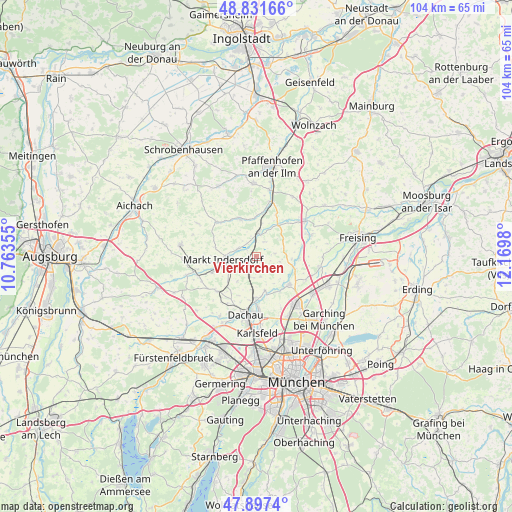
Vierkirchen GPS coordinates[2]
48° 22' 0.012" North, 11° 28' 0.012" East
| Map corner | latitude | longitude |
|---|---|---|
| Upper-left | 48.83166°, | 10.76355° |
| Center: | 48.36667°, | 11.46667° |
| Lower-right: | 47.8974°, | 12.1698° |
| Map W x H: | 103.9×103.9 km | = 64.6×64.6mi |
| max Lat: | 55.01917° ⇑90.6% North |
| Vierkirchen: | 48.36667° |
| min Lat: | ⇓9.4% South 47.40724° |
| min Long | Vierkirchen | max Long |
| 5.92978° | 11.46667° | 14.98853° |
| W 73.8%⇐ | ⇒26.2% E |
Elevation
Elevation of Vierkirchen is 485 m = 1591 ft, and this is 235.9 m = 774 ft above average elevation for this country.
| Max E: |
1256 m = 4121 ft | 13.1% |
| Vierkirchen | 485 m 1591 ft | |
| Avg. | 249.1 m = 817 ft | |
Min E: |
-5 m = -16 ft | 86.9% |
See also: Germany elevation on elevation.city.
Geographical zone
Vierkirchen is located in North temperate zone (between Tropic of Cancer and the Arctic Circle). Distance of this North polar circle is 2023.3 km =1257.2 mi to North.| Distance of | km | miles | from Vierkirchen |
|---|---|---|---|
| North Pole | 4629.2 | 2876.5 | to North |
| Arctic Circle | 2023.3 | 1257.2 | to North |
| Tropic Cancer | 2772 | 1722.4 | to South |
| Equator | 5377.9 | 3341.7 | to South |


Nearby cities:
15 places around Vierkirchen: (largest is in red/bold)
• Dachau
12.1 km =7.5 mi,  191°
191°
• Fahrenzhausen
6.7 km =4.2 mi,  102°
102°
• Haimhausen
8.6 km =5.3 mi,  131°
131°
• Hebertshausen
8.6 km =5.3 mi,  180°
180°
• Hilgertshausen-Tandern
10.9 km =6.8 mi,  310°
310°
• Hohenkammer
7.7 km =4.8 mi,  34°
34°
• Jetzendorf
8.3 km =5.2 mi,  333°
333°
• Kranzberg
11.6 km =7.2 mi,  67°
67°
• Markt Indersdorf
6.6 km =4.1 mi,  264°
264°
• Petershausen
4.8 km =3 mi,  3°
3°
• Reichertshausen
11.7 km =7.3 mi,  18°
18°
• Röhrmoos
4.4 km =2.7 mi,  199°
199°
• Schwabhausen
9 km =5.6 mi,  295°
295°
• Schwabhausen
10.8 km =6.7 mi,  229°
229°
• Weichs
4.1 km =2.5 mi, 296°
Sources, notices
• [Note1] Compared only with cities in Germany existing in our database
• [Src1] Map data: © OpenStreetMap contributors (CC-BY-SA)
• [Src2] Other city data from geonames.org with taken over terms of usage.
• [Src3] Geographical zone / Annual Mean Temperature by Robert A. Rohde @ Wikipedia
