Reichertshausen geodata
Reichertshausen (Bavaria) is a seat of a fourth-order administrative division; located in Germany in Europe/Berlin (GMT+2) time zone. In our database, there are 11009 cities with bigger population. Compared to other cities in Germany, 89.5% of cities are located further ↑North; 74.5% of cities are located further ←West and 83.8% of cities have lower elevation than Reichertshausen. Note1
Administrative division(s):
- Level 1: Bavaria
- Level 2: Upper Bavaria
- Level 3: Landkreis Pfaffenhofen an der Ilm
- Level 4: Reichertshausen


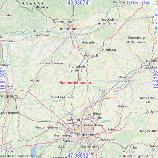
Reichertshausen GPS coordinates[2]
48° 28' 0.012" North, 11° 31' 0.012" East
| Map corner | latitude | longitude |
|---|---|---|
| Upper-left | 48.93074°, | 10.81355° |
| Center: | 48.46667°, | 11.51667° |
| Lower-right: | 47.99832°, | 12.2198° |
| Map W x H: | 103.7×103.7 km | = 64.4×64.4mi |
| max Lat: | 55.01917° ⇑89.5% North |
| Reichertshausen: | 48.46667° |
| min Lat: | ⇓10.5% South 47.40724° |
| min Long | Reichertshausen | max Long |
| 5.92978° | 11.51667° | 14.98853° |
| W 74.5%⇐ | ⇒25.5% E |
Elevation
Elevation of Reichertshausen is 460 m = 1509 ft, and this is 210.9 m = 692 ft above average elevation for this country.
| Max E: |
1256 m = 4121 ft | 16.2% |
| Reichertshausen | 460 m 1509 ft | |
| Avg. | 249.1 m = 817 ft | |
Min E: |
-5 m = -16 ft | 83.8% |
See also: Germany elevation on elevation.city.
Geographical zone
Reichertshausen is located in North temperate zone (between Tropic of Cancer and the Arctic Circle). Distance of this North polar circle is 2012.2 km =1250.3 mi to North.| Distance of | km | miles | from Reichertshausen |
|---|---|---|---|
| North Pole | 4618.1 | 2869.6 | to North |
| Arctic Circle | 2012.2 | 1250.3 | to North |
| Tropic Cancer | 2783.1 | 1729.3 | to South |
| Equator | 5389 | 3348.6 | to South |


Nearby cities:
15 places around Reichertshausen: (largest is in red/bold)
• Allershausen
7.2 km =4.5 mi,  121°
121°
• Gerolsbach
11.8 km =7.3 mi,  284°
284°
• Hettenshausen
3.9 km =2.4 mi,  341°
341°
• Hohenkammer
4.8 km =3 mi,  172°
172°
• Ilmmünster
2.2 km =1.4 mi,  326°
326°
• Jetzendorf
8.3 km =5.2 mi,  243°
243°
• Kirchdorf
10.2 km =6.3 mi,  94°
94°
• Kranzberg
9.8 km =6.1 mi,  133°
133°
• Paunzhausen
3.7 km =2.3 mi,  75°
75°
• Petershausen
7.2 km =4.5 mi,  208°
208°
• Pfaffenhofen an der Ilm
7.2 km =4.5 mi,  353°
353°
• Scheyern
5.2 km =3.2 mi,  315°
315°
• Schweitenkirchen
7.7 km =4.8 mi,  57°
57°
• Vierkirchen
11.7 km =7.3 mi,  198°
198°
• Weichs
11.8 km =7.3 mi,  218°
218°
Sources, notices
• [Note1] Compared only with cities in Germany existing in our database
• [Src1] Map data: © OpenStreetMap contributors (CC-BY-SA)
• [Src2] Other city data from geonames.org with taken over terms of usage.
• [Src3] Geographical zone / Annual Mean Temperature by Robert A. Rohde @ Wikipedia
