Ottersweier geodata
Ottersweier (Baden-Württemberg) is a seat of a fourth-order administrative division; located in Germany in Europe/Berlin (GMT+2) time zone. With population of 6,441 people, there are 2321 cities with bigger population in this country. Compared to other cities in Germany, 86.9% of cities are located further ↑North; 75.3% of cities are located further →East and 61.8% of cities have higher elevation than Ottersweier. Note1
Administrative division(s):
- Level 1: Baden-Württemberg
- Level 2: Karlsruhe Region
- Level 3: Landkreis Rastatt
- Level 4: Ottersweier


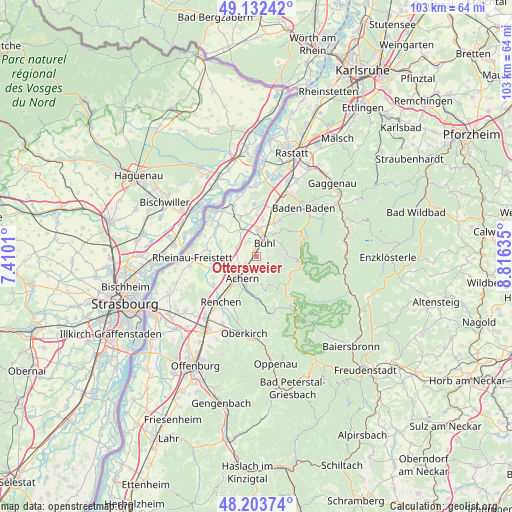
Ottersweier GPS coordinates[2]
48° 40' 12.792" North, 8° 6' 47.628" East
| Map corner | latitude | longitude |
|---|---|---|
| Upper-left | 49.13242°, | 7.4101° |
| Center: | 48.67022°, | 8.11323° |
| Lower-right: | 48.20374°, | 8.81635° |
| Map W x H: | 103.3×103.3 km | = 64.2×64.2mi |
| max Lat: | 55.01917° ⇑86.9% North |
| Ottersweier: | 48.67022° |
| min Lat: | ⇓13.1% South 47.40724° |
| min Long | Ottersweier | max Long |
| 5.92978° | 8.11323° | 14.98853° |
| W 24.7%⇐ | ⇒75.3% E |
Elevation
Elevation of Ottersweier is 140 m = 459 ft, and this is 109.1 m = 358 ft below average elevation for this country.
| Max E: |
1256 m = 4121 ft | 61.8% |
| Avg. | 249.1 m = 817 ft | |
| Ottersweier | 140 m = 459 ft | |
Min E: |
-5 m = -16 ft | 38.2% |
See also: Germany elevation on elevation.city.
Geographical zone
Ottersweier is located in North temperate zone (between Tropic of Cancer and the Arctic Circle). Distance of this North polar circle is 1989.6 km =1236.3 mi to North.| Distance of | km | miles | from Ottersweier |
|---|---|---|---|
| North Pole | 4595.4 | 2855.4 | to North |
| Arctic Circle | 1989.6 | 1236.3 | to North |
| Tropic Cancer | 2805.7 | 1743.4 | to South |
| Equator | 5411.6 | 3362.6 | to South |


Nearby cities:
15 places around Ottersweier: (largest is in red/bold)
• Achern
5.1 km =3.2 mi,  212°
212°
• Bühl
3.4 km =2.1 mi,  28°
28°
• Bühlertal
5.8 km =3.6 mi,  72°
72°
• Kappelrodeck
8.7 km =5.4 mi,  178°
178°
• Lauf
2.7 km =1.7 mi,  146°
146°
• Lichtenau
10.1 km =6.3 mi,  307°
307°
• Ottenhofen
7.4 km =4.6 mi,  9°
9°
• Ottenhöfen im Schwarzwald
11.8 km =7.3 mi,  166°
166°
• Renchen
11.7 km =7.3 mi,  218°
218°
• Sasbach
3.7 km =2.3 mi,  202°
202°
• Sasbachwalden
6.1 km =3.8 mi, 166°
• Schwarzach
10.2 km =6.3 mi,  327°
327°
• Seebach
11.3 km =7 mi,  158°
158°
• Sinzheim
11.4 km =7.1 mi,  20°
20°
• Zell
4.4 km =2.7 mi,  303°
303°
Sources, notices
• [Note1] Compared only with cities in Germany existing in our database
• [Src1] Map data: © OpenStreetMap contributors (CC-BY-SA)
• [Src2] Other city data from geonames.org with taken over terms of usage.
• [Src3] Geographical zone / Annual Mean Temperature by Robert A. Rohde @ Wikipedia
