Sasbach geodata
Sasbach (Baden-Württemberg) is a seat of a fourth-order administrative division; located in Germany in Europe/Berlin (GMT+2) time zone. With population of 5,599 people, there are 2594 cities with bigger population in this country. Compared to other cities in Germany, 87.3% of cities are located further ↑North; 75.6% of cities are located further →East and 61.5% of cities have higher elevation than Sasbach. Note1
Administrative division(s):
- Level 1: Baden-Württemberg
- Level 2: Freiburg Region
- Level 3: Ortenaukreis
- Level 4: Sasbach


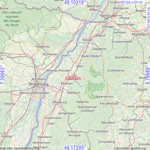
Sasbach GPS coordinates[2]
48° 38' 22.956" North, 8° 5' 37.5" East
| Map corner | latitude | longitude |
|---|---|---|
| Upper-left | 49.10219°, | 7.39063° |
| Center: | 48.63971°, | 8.09375° |
| Lower-right: | 48.17295°, | 8.79688° |
| Map W x H: | 103.3×103.3 km | = 64.2×64.2mi |
| max Lat: | 55.01917° ⇑87.3% North |
| Sasbach: | 48.63971° |
| min Lat: | ⇓12.7% South 47.40724° |
| min Long | Sasbach | max Long |
| 5.92978° | 8.09375° | 14.98853° |
| W 24.4%⇐ | ⇒75.6% E |
Elevation
Elevation of Sasbach is 142 m = 466 ft, and this is 107.1 m = 351 ft below average elevation for this country.
| Max E: |
1256 m = 4121 ft | 61.5% |
| Avg. | 249.1 m = 817 ft | |
| Sasbach | 142 m = 466 ft | |
Min E: |
-5 m = -16 ft | 38.5% |
See also: Germany elevation on elevation.city.
Geographical zone
Sasbach is located in North temperate zone (between Tropic of Cancer and the Arctic Circle). Distance of this North polar circle is 1992.9 km =1238.3 mi to North.| Distance of | km | miles | from Sasbach |
|---|---|---|---|
| North Pole | 4598.8 | 2857.6 | to North |
| Arctic Circle | 1992.9 | 1238.3 | to North |
| Tropic Cancer | 2802.3 | 1741.3 | to South |
| Equator | 5408.2 | 3360.5 | to South |


Nearby cities:
15 places around Sasbach: (largest is in red/bold)
• Achern
1.6 km =1 mi,  233°
233°
• Bühl
7 km =4.3 mi,  25°
25°
• Bühlertal
8.7 km =5.4 mi,  53°
53°
• Haslach
8.7 km =5.4 mi,  198°
198°
• Kappelrodeck
5.6 km =3.5 mi,  162°
162°
• Lauf
3.1 km =1.9 mi,  68°
68°
• Lichtenau
11.6 km =7.2 mi,  325°
325°
• Ottenhofen
11 km =6.8 mi,  13°
13°
• Ottenhöfen im Schwarzwald
9.1 km =5.7 mi,  153°
153°
• Ottersweier
3.7 km =2.3 mi,  22°
22°
• Renchen
8.2 km =5.1 mi, 226°
• Rheinau
11.9 km =7.4 mi,  284°
284°
• Sasbachwalden
3.9 km =2.4 mi,  131°
131°
• Seebach
9 km =5.6 mi,  141°
141°
• Zell
6.3 km =3.9 mi,  338°
338°
Sources, notices
• [Note1] Compared only with cities in Germany existing in our database
• [Src1] Map data: © OpenStreetMap contributors (CC-BY-SA)
• [Src2] Other city data from geonames.org with taken over terms of usage.
• [Src3] Geographical zone / Annual Mean Temperature by Robert A. Rohde @ Wikipedia
