Ostritz geodata
Ostritz (Saxony) is a populated place; located in Germany in Europe/Berlin (GMT+2) time zone. With population of 2,988 people, there are 4011 cities with bigger population in this country. Compared to other cities in Germany, 58.3% of cities are located further ↓South; 100% of cities are located further ←West and 52.1% of cities have higher elevation than Ostritz. Note1


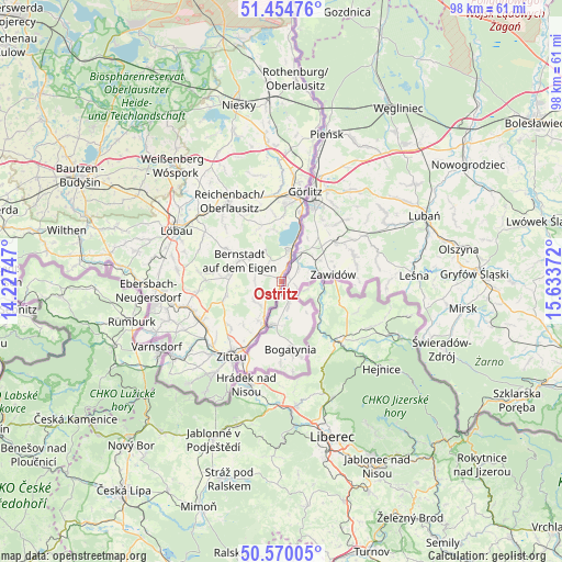
Ostritz GPS coordinates[2]
51° 0' 52.236" North, 14° 55' 50.124" East
| Map corner | latitude | longitude |
|---|---|---|
| Upper-left | 51.45476°, | 14.22747° |
| Center: | 51.01451°, | 14.93059° |
| Lower-right: | 50.57005°, | 15.63372° |
| Map W x H: | 98.4×98.4 km | = 61.1×61.1mi |
| max Lat: | 55.01917° ⇑41.7% North |
| Ostritz: | 51.01451° |
| min Lat: | ⇓58.3% South 47.40724° |
| min Long | Ostritz | max Long |
| 5.92978° | 14.93059° | 14.98853° |
| W 100%⇐ | ⇒0% E |
Elevation
Elevation of Ostritz is 211 m = 692 ft, and this is 38.1 m = 125 ft below average elevation for this country.
| Max E: |
1256 m = 4121 ft | 52.1% |
| Avg. | 249.1 m = 817 ft | |
| Ostritz | 211 m = 692 ft | |
Min E: |
-5 m = -16 ft | 47.9% |
See also: Germany elevation on elevation.city.
Geographical zone
Ostritz is located in North temperate zone (between Tropic of Cancer and the Arctic Circle). Distance of this North polar circle is 1728.9 km =1074.3 mi to North.| Distance of | km | miles | from Ostritz |
|---|---|---|---|
| North Pole | 4334.8 | 2693.5 | to North |
| Arctic Circle | 1728.9 | 1074.3 | to North |
| Tropic Cancer | 3066.4 | 1905.4 | to South |
| Equator | 5672.3 | 3524.6 | to South |


Nearby cities:
15 places around Ostritz: (largest is in red/bold)
• Bernstadt
8.1 km =5 mi,  296°
296°
• Eibau
19.1 km =11.9 mi,  259°
259°
• Großhennersdorf
10.5 km =6.5 mi,  252°
252°
• Görlitz
16.2 km =10.1 mi,  14°
14°
• Herrnhut
13.1 km =8.1 mi,  270°
270°
• Hirschfelde
8.4 km =5.2 mi,  202°
202°
• Markersdorf
13.6 km =8.5 mi,  345°
345°
• Mittelherwigsdorf
15.8 km =9.8 mi,  226°
226°
• Olbersdorf
19.3 km =12 mi,  215°
215°
• Reichenbach
16.7 km =10.4 mi,  327°
327°
• Schlegel
5.6 km =3.5 mi, 222°
• Schönau-Berzdorf
6.4 km =4 mi, 329°
• Sohland am Rotstein
15.3 km =9.5 mi,  317°
317°
• Strahwalde
14.5 km =9 mi,  276°
276°
• Zittau
15.6 km =9.7 mi,  213°
213°
Sources, notices
• [Note1] Compared only with cities in Germany existing in our database
• [Src1] Map data: © OpenStreetMap contributors (CC-BY-SA)
• [Src2] Other city data from geonames.org with taken over terms of usage.
• [Src3] Geographical zone / Annual Mean Temperature by Robert A. Rohde @ Wikipedia
