Großhennersdorf geodata
Großhennersdorf (Saxony) is a populated place; located in Germany in Europe/Berlin (GMT+2) time zone. With population of 1,539 people, there are 5798 cities with bigger population in this country. Compared to other cities in Germany, 57.9% of cities are located further ↓South; 99.9% of cities are located further ←West and 62.8% of cities have lower elevation than Großhennersdorf. Note1


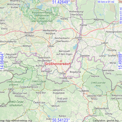
Großhennersdorf GPS coordinates[2]
50° 59' 9.492" North, 14° 47' 15.936" East
| Map corner | latitude | longitude |
|---|---|---|
| Upper-left | 51.42649°, | 14.08464° |
| Center: | 50.98597°, | 14.78776° |
| Lower-right: | 50.54123°, | 15.49089° |
| Map W x H: | 98.4×98.4 km | = 61.1×61.1mi |
| max Lat: | 55.01917° ⇑42.1% North |
| Großhennersdorf: | 50.98597° |
| min Lat: | ⇓57.9% South 47.40724° |
| min Long | Großhennersdor | max Long |
| 5.92978° | 14.78776° | 14.98853° |
| W 99.9%⇐ | ⇒0.099999999999994% E |
Elevation
Elevation of Großhennersdorf is 307 m = 1007 ft, and this is 57.9 m = 190 ft above average elevation for this country.
| Max E: |
1256 m = 4121 ft | 37.2% |
| Großhennersdorf | 307 m 1007 ft | |
| Avg. | 249.1 m = 817 ft | |
Min E: |
-5 m = -16 ft | 62.8% |
See also: Germany elevation on elevation.city.
Geographical zone
Großhennersdorf is located in North temperate zone (between Tropic of Cancer and the Arctic Circle). Distance of this North polar circle is 1732.1 km =1076.3 mi to North.| Distance of | km | miles | from Großhennersdorf |
|---|---|---|---|
| North Pole | 4338 | 2695.5 | to North |
| Arctic Circle | 1732.1 | 1076.3 | to North |
| Tropic Cancer | 3063.2 | 1903.4 | to South |
| Equator | 5669.1 | 3522.6 | to South |


Nearby cities:
15 places around Großhennersdorf: (largest is in red/bold)
• Bernstadt
7.4 km =4.6 mi,  22°
22°
• Bertsdorf-Hörnitz
11.7 km =7.3 mi,  197°
197°
• Eibau
8.8 km =5.5 mi,  267°
267°
• Großschönau
12 km =7.5 mi,  217°
217°
• Hainewalde
10.3 km =6.4 mi,  214°
214°
• Herrnhut
4.6 km =2.9 mi,  317°
317°
• Hirschfelde
8.2 km =5.1 mi,  124°
124°
• Leutersdorf
10.4 km =6.5 mi,  247°
247°
• Mittelherwigsdorf
7.8 km =4.8 mi,  190°
190°
• Niedercunnersdorf
11.8 km =7.3 mi,  309°
309°
• Ostritz
10.5 km =6.5 mi,  72°
72°
• Schlegel
6.3 km =3.9 mi,  98°
98°
• Schönau-Berzdorf
11 km =6.8 mi,  37°
37°
• Strahwalde
6.5 km =4 mi, 316°
• Zittau
9.9 km =6.2 mi,  171°
171°
Sources, notices
• [Note1] Compared only with cities in Germany existing in our database
• [Src1] Map data: © OpenStreetMap contributors (CC-BY-SA)
• [Src2] Other city data from geonames.org with taken over terms of usage.
• [Src3] Geographical zone / Annual Mean Temperature by Robert A. Rohde @ Wikipedia
