Bernstadt geodata
Bernstadt (Saxony) is a populated place; located in Germany in Europe/Berlin (GMT+2) time zone. With population of 4,046 people, there are 3272 cities with bigger population in this country. Compared to other cities in Germany, 58.9% of cities are located further ↓South; 99.9% of cities are located further ←West and 51% of cities have lower elevation than Bernstadt. Note1
Administrative division(s):
- Level 1: Saxony
- Level 3: Landkreis Görlitz
- Level 4: Bernstadt a. d. Eigen


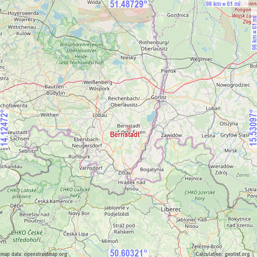
Bernstadt GPS coordinates[2]
51° 2' 50.496" North, 14° 49' 40.224" East
| Map corner | latitude | longitude |
|---|---|---|
| Upper-left | 51.48729°, | 14.12472° |
| Center: | 51.04736°, | 14.82784° |
| Lower-right: | 50.60321°, | 15.53097° |
| Map W x H: | 98.3×98.3 km | = 61.1×61.1mi |
| max Lat: | 55.01917° ⇑41.1% North |
| Bernstadt: | 51.04736° |
| min Lat: | ⇓58.9% South 47.40724° |
| min Long | Bernstadt | max Long |
| 5.92978° | 14.82784° | 14.98853° |
| W 99.9%⇐ | ⇒0.099999999999994% E |
Elevation
Elevation of Bernstadt is 233 m = 764 ft, and this is 16.1 m = 53 ft below average elevation for this country.
| Max E: |
1256 m = 4121 ft | 49% |
| Avg. | 249.1 m = 817 ft | |
| Bernstadt | 233 m = 764 ft | |
Min E: |
-5 m = -16 ft | 51% |
See also: Germany elevation on elevation.city.
Geographical zone
Bernstadt is located in North temperate zone (between Tropic of Cancer and the Arctic Circle). Distance of this North polar circle is 1725.2 km =1072 mi to North.| Distance of | km | miles | from Bernstadt |
|---|---|---|---|
| North Pole | 4331.1 | 2691.2 | to North |
| Arctic Circle | 1725.2 | 1072 | to North |
| Tropic Cancer | 3070 | 1907.6 | to South |
| Equator | 5675.9 | 3526.8 | to South |


Nearby cities:
15 places around Bernstadt: (largest is in red/bold)
• Eibau
13.6 km =8.5 mi,  238°
238°
• Großhennersdorf
7.4 km =4.6 mi,  202°
202°
• Großschweidnitz
13.1 km =8.1 mi,  280°
280°
• Herrnhut
6.8 km =4.2 mi, 239°
• Hirschfelde
12.1 km =7.5 mi,  160°
160°
• Löbau
12.6 km =7.8 mi,  297°
297°
• Markersdorf
10.3 km =6.4 mi,  22°
22°
• Mittelherwigsdorf
15.1 km =9.4 mi, 196°
• Niedercunnersdorf
11.9 km =7.4 mi,  273°
273°
• Ostritz
8.1 km =5 mi,  116°
116°
• Reichenbach
10.6 km =6.6 mi,  350°
350°
• Schlegel
8.5 km =5.3 mi, 156°
• Schönau-Berzdorf
4.3 km =2.7 mi,  64°
64°
• Sohland am Rotstein
8.3 km =5.2 mi,  338°
338°
• Strahwalde
7.6 km =4.7 mi,  254°
254°
Sources, notices
• [Note1] Compared only with cities in Germany existing in our database
• [Src1] Map data: © OpenStreetMap contributors (CC-BY-SA)
• [Src2] Other city data from geonames.org with taken over terms of usage.
• [Src3] Geographical zone / Annual Mean Temperature by Robert A. Rohde @ Wikipedia
