Oberbillig geodata
Oberbillig (Rheinland-Pfalz) is a seat of a fourth-order administrative division; located in Germany in Europe/Berlin (GMT+2) time zone. With population of 851 people, there are 7697 cities with bigger population in this country. Compared to other cities in Germany, 71.2% of cities are located further ↑North; 97.7% of cities are located further →East and 58.3% of cities have higher elevation than Oberbillig. Note1
Administrative division(s):
- Level 1: Rheinland-Pfalz
- Level 3: Landkreis Trier-Saarburg
- Level 4: Oberbillig


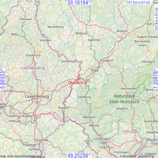
Oberbillig GPS coordinates[2]
49° 42' 33.768" North, 6° 30' 23.94" East
| Map corner | latitude | longitude |
|---|---|---|
| Upper-left | 50.16194°, | 5.80353° |
| Center: | 49.70938°, | 6.50665° |
| Lower-right: | 49.25256°, | 7.20978° |
| Map W x H: | 101.1×101.1 km | = 62.8×62.8mi |
| max Lat: | 55.01917° ⇑71.2% North |
| Oberbillig: | 49.70938° |
| min Lat: | ⇓28.8% South 47.40724° |
| min Long | Oberbillig | max Long |
| 5.92978° | 6.50665° | 14.98853° |
| W 2.3%⇐ | ⇒97.7% E |
Elevation
Elevation of Oberbillig is 165 m = 541 ft, and this is 84.1 m = 276 ft below average elevation for this country.
| Max E: |
1256 m = 4121 ft | 58.3% |
| Avg. | 249.1 m = 817 ft | |
| Oberbillig | 165 m = 541 ft | |
Min E: |
-5 m = -16 ft | 41.7% |
See also: Germany elevation on elevation.city.
Geographical zone
Oberbillig is located in North temperate zone (between Tropic of Cancer and the Arctic Circle). Distance of this North polar circle is 1874 km =1164.4 mi to North.| Distance of | km | miles | from Oberbillig |
|---|---|---|---|
| North Pole | 4479.9 | 2783.7 | to North |
| Arctic Circle | 1874 | 1164.4 | to North |
| Tropic Cancer | 2921.2 | 1815.1 | to South |
| Equator | 5527.2 | 3434.4 | to South |


Nearby cities:
15 places around Oberbillig: (largest is in red/bold)
• Ayl
9 km =5.6 mi,  159°
159°
• Igel
3.5 km =2.2 mi,  88°
88°
• Kanzem
7 km =4.3 mi,  132°
132°
• Konz
5.1 km =3.2 mi,  101°
101°
• Langsur
1.8 km =1.1 mi,  341°
341°
• Mannebach
8.5 km =5.3 mi,  175°
175°
• Nittel
7.8 km =4.8 mi,  211°
211°
• Onsdorf
6.8 km =4.2 mi,  194°
194°
• Tawern
4.8 km =3 mi,  171°
171°
• Temmels
3.7 km =2.3 mi,  232°
232°
• Trierweiler
7 km =4.3 mi,  33°
33°
• Wasserliesch
2.4 km =1.5 mi, 95°
• Wawern
7.3 km =4.5 mi,  154°
154°
• Wellen
7.1 km =4.4 mi, 228°
• Wiltingen
8.3 km =5.2 mi, 132°
Sources, notices
• [Note1] Compared only with cities in Germany existing in our database
• [Src1] Map data: © OpenStreetMap contributors (CC-BY-SA)
• [Src2] Other city data from geonames.org with taken over terms of usage.
• [Src3] Geographical zone / Annual Mean Temperature by Robert A. Rohde @ Wikipedia
