Odernheim geodata
Odernheim (Rheinland-Pfalz) is a populated place; located in Germany in Europe/Berlin (GMT+2) time zone. With population of 1,776 people, there are 5386 cities with bigger population in this country. Compared to other cities in Germany, 69.8% of cities are located further ↑North; 82.9% of cities are located further →East and 61.1% of cities have higher elevation than Odernheim. Note1
Administrative division(s):
- Level 1: Rheinland-Pfalz
- Level 3: Landkreis Bad Kreuznach
- Level 4: Odernheim am Glan


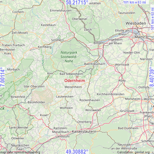
Odernheim GPS coordinates[2]
49° 45' 54.396" North, 7° 42' 15.372" East
| Map corner | latitude | longitude |
|---|---|---|
| Upper-left | 50.21715°, | 7.00114° |
| Center: | 49.76511°, | 7.70427° |
| Lower-right: | 49.30882°, | 8.40739° |
| Map W x H: | 101×101 km | = 62.8×62.8mi |
| max Lat: | 55.01917° ⇑69.8% North |
| Odernheim: | 49.76511° |
| min Lat: | ⇓30.2% South 47.40724° |
| min Long | Odernheim | max Long |
| 5.92978° | 7.70427° | 14.98853° |
| W 17.1%⇐ | ⇒82.9% E |
Elevation
Elevation of Odernheim is 145 m = 476 ft, and this is 104.1 m = 342 ft below average elevation for this country.
| Max E: |
1256 m = 4121 ft | 61.1% |
| Avg. | 249.1 m = 817 ft | |
| Odernheim | 145 m = 476 ft | |
Min E: |
-5 m = -16 ft | 38.9% |
See also: Germany elevation on elevation.city.
Geographical zone
Odernheim is located in North temperate zone (between Tropic of Cancer and the Arctic Circle). Distance of this North polar circle is 1867.8 km =1160.6 mi to North.| Distance of | km | miles | from Odernheim |
|---|---|---|---|
| North Pole | 4473.7 | 2779.8 | to North |
| Arctic Circle | 1867.8 | 1160.6 | to North |
| Tropic Cancer | 2927.4 | 1819 | to South |
| Equator | 5533.4 | 3438.3 | to South |


Nearby cities:
15 places around Odernheim: (largest is in red/bold)
• Abtweiler
4.2 km =2.6 mi,  246°
246°
• Boos
4 km =2.5 mi,  12°
12°
• Duchroth
2.9 km =1.8 mi,  45°
45°
• Hallgarten
6.1 km =3.8 mi,  96°
96°
• Lettweiler
4.1 km =2.5 mi,  149°
149°
• Meddersheim
6.4 km =4 mi,  281°
281°
• Niederhausen
6.9 km =4.3 mi,  55°
55°
• Obermoschel
6.4 km =4 mi,  130°
130°
• Oberstreit
3.9 km =2.4 mi,  355°
355°
• Raumbach
6.6 km =4.1 mi,  215°
215°
• Rehborn
3.8 km =2.4 mi,  203°
203°
• Schloßböckelheim
5.1 km =3.2 mi,  40°
40°
• Staudernheim
1.7 km =1.1 mi,  319°
319°
• Unkenbach
6.3 km =3.9 mi, 148°
• Waldböckelheim
5.8 km =3.6 mi, 8°
Sources, notices
• [Note1] Compared only with cities in Germany existing in our database
• [Src1] Map data: © OpenStreetMap contributors (CC-BY-SA)
• [Src2] Other city data from geonames.org with taken over terms of usage.
• [Src3] Geographical zone / Annual Mean Temperature by Robert A. Rohde @ Wikipedia
