Niederburg geodata
Niederburg (Rheinland-Pfalz) is a seat of a fourth-order administrative division; located in Germany in Europe/Berlin (GMT+2) time zone. With population of 699 people, there are 8319 cities with bigger population in this country. Compared to other cities in Germany, 61% of cities are located further ↑North; 83.1% of cities are located further →East and 59.3% of cities have lower elevation than Niederburg. Note1
Administrative division(s):
- Level 1: Rheinland-Pfalz
- Level 3: Rhein-Hunsrück-Kreis
- Level 4: Niederburg


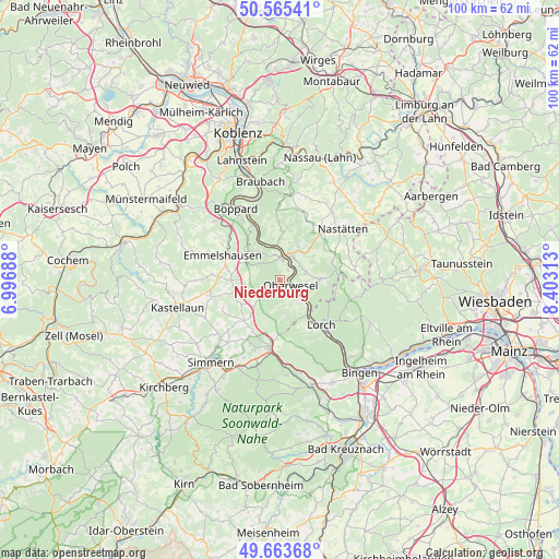
Niederburg GPS coordinates[2]
50° 7' 0.012" North, 7° 42' 0" East
| Map corner | latitude | longitude |
|---|---|---|
| Upper-left | 50.56541°, | 6.99688° |
| Center: | 50.11667°, | 7.7° |
| Lower-right: | 49.66368°, | 8.40313° |
| Map W x H: | 100.3×100.3 km | = 62.3×62.3mi |
| max Lat: | 55.01917° ⇑61% North |
| Niederburg: | 50.11667° |
| min Lat: | ⇓39% South 47.40724° |
| min Long | Niederburg | max Long |
| 5.92978° | 7.7° | 14.98853° |
| W 16.9%⇐ | ⇒83.1% E |
Elevation
Elevation of Niederburg is 285 m = 935 ft, and this is 35.9 m = 118 ft above average elevation for this country.
| Max E: |
1256 m = 4121 ft | 40.7% |
| Niederburg | 285 m 935 ft | |
| Avg. | 249.1 m = 817 ft | |
Min E: |
-5 m = -16 ft | 59.3% |
See also: Germany elevation on elevation.city.
Geographical zone
Niederburg is located in North temperate zone (between Tropic of Cancer and the Arctic Circle). Distance of this North polar circle is 1828.7 km =1136.3 mi to North.| Distance of | km | miles | from Niederburg |
|---|---|---|---|
| North Pole | 4434.6 | 2755.5 | to North |
| Arctic Circle | 1828.7 | 1136.3 | to North |
| Tropic Cancer | 2966.5 | 1843.3 | to South |
| Equator | 5572.5 | 3462.6 | to South |


Nearby cities:
15 places around Niederburg: (largest is in red/bold)
• Badenhard
4.8 km =3 mi,  270°
270°
• Birkheim
5.9 km =3.7 mi, 270°
• Bornich
4.8 km =3 mi,  76°
76°
• Damscheid
2.2 km =1.4 mi,  212°
212°
• Dörscheid
4 km =2.5 mi,  117°
117°
• Kaub
5.4 km =3.4 mi,  126°
126°
• Nochern
5.7 km =3.5 mi,  12°
12°
• Oberwesel
2.1 km =1.3 mi, 118°
• Patersberg
4.4 km =2.7 mi,  32°
32°
• Perscheid
5.6 km =3.5 mi,  180°
180°
• Reichenberg
6 km =3.7 mi,  52°
52°
• Sankt Goar
3.6 km =2.2 mi, 8°
• Sankt Goarshausen
4.7 km =2.9 mi, 11°
• Urbar
2.2 km =1.4 mi, 32°
• Utzenhain
5.1 km =3.2 mi,  291°
291°
Sources, notices
• [Note1] Compared only with cities in Germany existing in our database
• [Src1] Map data: © OpenStreetMap contributors (CC-BY-SA)
• [Src2] Other city data from geonames.org with taken over terms of usage.
• [Src3] Geographical zone / Annual Mean Temperature by Robert A. Rohde @ Wikipedia
