Trechtingshausen geodata
Trechtingshausen (Rheinland-Pfalz) is a seat of a fourth-order administrative division; located in Germany in Europe/Berlin (GMT+2) time zone. With population of 1,053 people, there are 6991 cities with bigger population in this country. Compared to other cities in Germany, 63.6% of cities are located further ↑North; 80.1% of cities are located further →East and 64.1% of cities have higher elevation than Trechtingshausen. Note1
Administrative division(s):
- Level 1: Rheinland-Pfalz
- Level 3: Landkreis Mainz-Bingen
- Level 4: Trechtingshausen


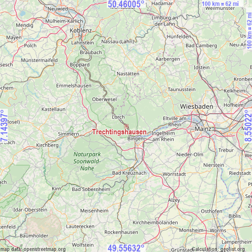
Trechtingshausen GPS coordinates[2]
50° 0' 37.116" North, 7° 50' 49.524" East
| Map corner | latitude | longitude |
|---|---|---|
| Upper-left | 50.46005°, | 7.14397° |
| Center: | 50.01031°, | 7.84709° |
| Lower-right: | 49.55632°, | 8.55022° |
| Map W x H: | 100.5×100.5 km | = 62.4×62.4mi |
| max Lat: | 55.01917° ⇑63.6% North |
| Trechtingshausen: | 50.01031° |
| min Lat: | ⇓36.4% South 47.40724° |
| min Long | Trechtingshause | max Long |
| 5.92978° | 7.84709° | 14.98853° |
| W 19.9%⇐ | ⇒80.1% E |
Elevation
Elevation of Trechtingshausen is 126 m = 413 ft, and this is 123.1 m = 404 ft below average elevation for this country.
| Max E: |
1256 m = 4121 ft | 64.1% |
| Avg. | 249.1 m = 817 ft | |
| Trechtingshausen | 126 m = 413 ft | |
Min E: |
-5 m = -16 ft | 35.9% |
See also: Germany elevation on elevation.city.
Geographical zone
Trechtingshausen is located in North temperate zone (between Tropic of Cancer and the Arctic Circle). Distance of this North polar circle is 1840.5 km =1143.6 mi to North.| Distance of | km | miles | from Trechtingshausen |
|---|---|---|---|
| North Pole | 4446.4 | 2762.9 | to North |
| Arctic Circle | 1840.5 | 1143.6 | to North |
| Tropic Cancer | 2954.7 | 1836 | to South |
| Equator | 5560.6 | 3455.2 | to South |


Nearby cities:
15 places around Trechtingshausen: (largest is in red/bold)
• Bacharach
7.6 km =4.7 mi,  313°
313°
• Bingen am Rhein
6.1 km =3.8 mi,  142°
142°
• Daxweiler
8.5 km =5.3 mi,  235°
235°
• Manubach
7.4 km =4.6 mi,  290°
290°
• Münster-Sarmsheim
8.2 km =5.1 mi,  155°
155°
• Niederheimbach
3.4 km =2.1 mi,  319°
319°
• Oberdiebach
5.2 km =3.2 mi,  299°
299°
• Oberheimbach
4.6 km =2.9 mi,  278°
278°
• Rüdesheim am Rhein
6.5 km =4 mi,  122°
122°
• Rümmelsheim
8.6 km =5.3 mi,  173°
173°
• Sauerthal
8.6 km =5.3 mi,  347°
347°
• Waldalgesheim
6.8 km =4.2 mi,  188°
188°
• Waldlaubersheim
8.6 km =5.3 mi, 186°
• Warmsroth
8.1 km =5 mi,  214°
214°
• Weiler
6.1 km =3.8 mi, 167°
Sources, notices
• [Note1] Compared only with cities in Germany existing in our database
• [Src1] Map data: © OpenStreetMap contributors (CC-BY-SA)
• [Src2] Other city data from geonames.org with taken over terms of usage.
• [Src3] Geographical zone / Annual Mean Temperature by Robert A. Rohde @ Wikipedia
