Manubach geodata
Manubach (Rheinland-Pfalz) is a seat of a fourth-order administrative division; located in Germany in Europe/Berlin (GMT+2) time zone. With population of 368 people, there are 9797 cities with bigger population in this country. Compared to other cities in Germany, 63% of cities are located further ↑North; 82.1% of cities are located further →East and 61.5% of cities have lower elevation than Manubach. Note1
Administrative division(s):
- Level 1: Rheinland-Pfalz
- Level 3: Landkreis Mainz-Bingen
- Level 4: Manubach


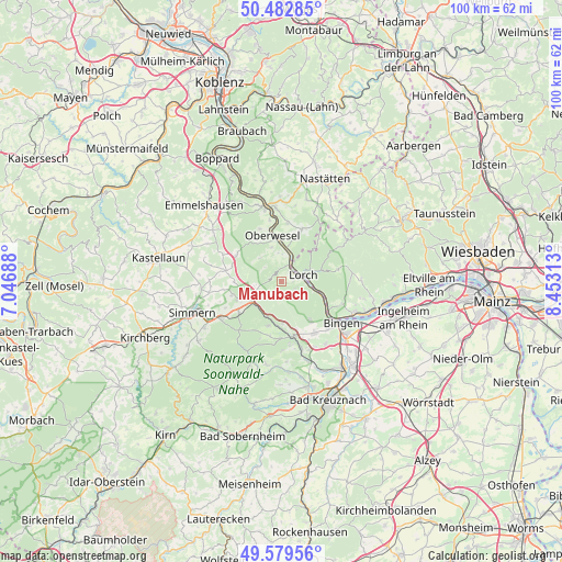
Manubach GPS coordinates[2]
50° 1' 59.988" North, 7° 45' 0" East
| Map corner | latitude | longitude |
|---|---|---|
| Upper-left | 50.48285°, | 7.04688° |
| Center: | 50.03333°, | 7.75° |
| Lower-right: | 49.57956°, | 8.45313° |
| Map W x H: | 100.4×100.4 km | = 62.4×62.4mi |
| max Lat: | 55.01917° ⇑63% North |
| Manubach: | 50.03333° |
| min Lat: | ⇓37% South 47.40724° |
| min Long | Manubach | max Long |
| 5.92978° | 7.75° | 14.98853° |
| W 17.9%⇐ | ⇒82.1% E |
Elevation
Elevation of Manubach is 299 m = 981 ft, and this is 49.9 m = 164 ft above average elevation for this country.
| Max E: |
1256 m = 4121 ft | 38.5% |
| Manubach | 299 m 981 ft | |
| Avg. | 249.1 m = 817 ft | |
Min E: |
-5 m = -16 ft | 61.5% |
See also: Germany elevation on elevation.city.
Geographical zone
Manubach is located in North temperate zone (between Tropic of Cancer and the Arctic Circle). Distance of this North polar circle is 1838 km =1142.1 mi to North.| Distance of | km | miles | from Manubach |
|---|---|---|---|
| North Pole | 4443.9 | 2761.3 | to North |
| Arctic Circle | 1838 | 1142.1 | to North |
| Tropic Cancer | 2957.3 | 1837.6 | to South |
| Equator | 5563.2 | 3456.8 | to South |


Nearby cities:
15 places around Manubach: (largest is in red/bold)
• Bacharach
3 km =1.9 mi,  27°
27°
• Breitscheid
4 km =2.5 mi,  297°
297°
• Daxweiler
7.4 km =4.6 mi,  180°
180°
• Dichtelbach
4.8 km =3 mi,  234°
234°
• Dörscheid
7.4 km =4.6 mi,  0°
0°
• Erbach
4.8 km =3 mi,  270°
270°
• Kaub
6.2 km =3.9 mi,  7°
7°
• Niederheimbach
4.8 km =3 mi,  90°
90°
• Oberdiebach
2.4 km =1.5 mi, 90°
• Oberheimbach
3 km =1.9 mi,  127°
127°
• Perscheid
5.1 km =3.2 mi,  316°
316°
• Rheinböllen
6.1 km =3.8 mi,  246°
246°
• Sauerthal
7.7 km =4.8 mi,  41°
41°
• Seibersbach
7.8 km =4.8 mi,  197°
197°
• Trechtingshausen
7.4 km =4.6 mi,  110°
110°
Sources, notices
• [Note1] Compared only with cities in Germany existing in our database
• [Src1] Map data: © OpenStreetMap contributors (CC-BY-SA)
• [Src2] Other city data from geonames.org with taken over terms of usage.
• [Src3] Geographical zone / Annual Mean Temperature by Robert A. Rohde @ Wikipedia
