Mündersbach geodata
Mündersbach (Rheinland-Pfalz) is a seat of a fourth-order administrative division; located in Germany in Europe/Berlin (GMT+2) time zone. With population of 806 people, there are 7871 cities with bigger population in this country. Compared to other cities in Germany, 50.3% of cities are located further ↑North; 82.3% of cities are located further →East and 66.1% of cities have lower elevation than Mündersbach. Note1


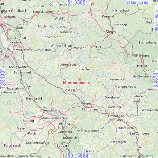
Mündersbach GPS coordinates[2]
50° 36' 23.004" North, 7° 44' 3.012" East
| Map corner | latitude | longitude |
|---|---|---|
| Upper-left | 51.05051°, | 7.03105° |
| Center: | 50.60639°, | 7.73417° |
| Lower-right: | 50.15804°, | 8.4373° |
| Map W x H: | 99.2×99.2 km | = 61.6×61.6mi |
| max Lat: | 55.01917° ⇑50.3% North |
| Mündersbach: | 50.60639° |
| min Lat: | ⇓49.7% South 47.40724° |
| min Long | Mündersbach | max Long |
| 5.92978° | 7.73417° | 14.98853° |
| W 17.7%⇐ | ⇒82.3% E |
Elevation
Elevation of Mündersbach is 329 m = 1079 ft, and this is 79.9 m = 262 ft above average elevation for this country.
| Max E: |
1256 m = 4121 ft | 33.9% |
| Mündersbach | 329 m 1079 ft | |
| Avg. | 249.1 m = 817 ft | |
Min E: |
-5 m = -16 ft | 66.1% |
See also: Germany elevation on elevation.city.
Geographical zone
Mündersbach is located in North temperate zone (between Tropic of Cancer and the Arctic Circle). Distance of this North polar circle is 1774.3 km =1102.5 mi to North.| Distance of | km | miles | from Mündersbach |
|---|---|---|---|
| North Pole | 4380.2 | 2721.7 | to North |
| Arctic Circle | 1774.3 | 1102.5 | to North |
| Tropic Cancer | 3021 | 1877.2 | to South |
| Equator | 5626.9 | 3496.4 | to South |


Nearby cities:
15 places around Mündersbach: (largest is in red/bold)
• Freirachdorf
2.8 km =1.7 mi,  205°
205°
• Hartenfels
5.2 km =3.2 mi,  133°
133°
• Herschbach
2.6 km =1.6 mi,  181°
181°
• Höchstenbach
3.1 km =1.9 mi,  13°
13°
• Maroth
4.5 km =2.8 mi,  224°
224°
• Merkelbach
5 km =3.1 mi,  29°
29°
• Roßbach
3.7 km =2.3 mi,  267°
267°
• Rückeroth
5 km =3.1 mi,  171°
171°
• Schenkelberg
4.3 km =2.7 mi, 126°
• Steinebach
5.1 km =3.2 mi,  85°
85°
• Steinen
5.3 km =3.3 mi,  118°
118°
• Wahlrod
5 km =3.1 mi,  345°
345°
• Welkenbach
3 km =1.9 mi, 349°
• Wied
4 km =2.5 mi,  24°
24°
• Winkelbach
4.8 km =3 mi,  359°
359°
Sources, notices
• [Note1] Compared only with cities in Germany existing in our database
• [Src1] Map data: © OpenStreetMap contributors (CC-BY-SA)
• [Src2] Other city data from geonames.org with taken over terms of usage.
• [Src3] Geographical zone / Annual Mean Temperature by Robert A. Rohde @ Wikipedia
