Nußdorf geodata
Nußdorf (Bavaria) is a seat of a fourth-order administrative division; located in Germany in Europe/Berlin (GMT+2) time zone. With population of 2,475 people, there are 4472 cities with bigger population in this country. Compared to other cities in Germany, 96.6% of cities are located further ↑North; 88.8% of cities are located further ←West and 94.9% of cities have lower elevation than Nußdorf. Note1
Administrative division(s):
- Level 1: Bavaria
- Level 2: Upper Bavaria
- Level 3: Landkreis Traunstein
- Level 4: Nußdorf


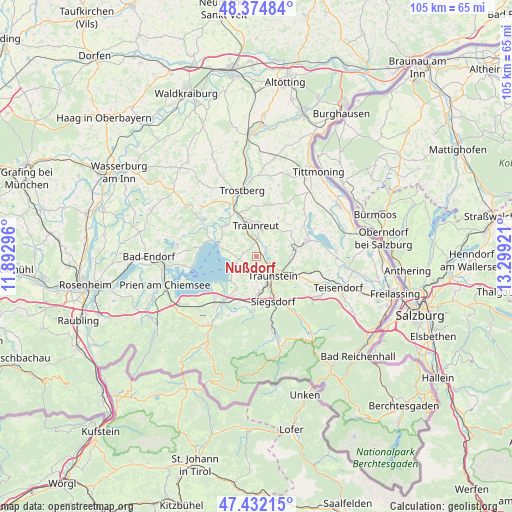
Nußdorf GPS coordinates[2]
47° 54' 20.304" North, 12° 35' 45.888" East
| Map corner | latitude | longitude |
|---|---|---|
| Upper-left | 48.37484°, | 11.89296° |
| Center: | 47.90564°, | 12.59608° |
| Lower-right: | 47.43215°, | 13.29921° |
| Map W x H: | 104.8×104.8 km | = 65.1×65.1mi |
| max Lat: | 55.01917° ⇑96.6% North |
| Nußdorf: | 47.90564° |
| min Lat: | ⇓3.4% South 47.40724° |
| min Long | Nußdorf | max Long |
| 5.92978° | 12.59608° | 14.98853° |
| W 88.8%⇐ | ⇒11.2% E |
Elevation
Elevation of Nußdorf is 597 m = 1959 ft, and this is 347.9 m = 1141 ft above average elevation for this country.
| Max E: |
1256 m = 4121 ft | 5.1% |
| Nußdorf | 597 m 1959 ft | |
| Avg. | 249.1 m = 817 ft | |
Min E: |
-5 m = -16 ft | 94.9% |
See also: Germany elevation on elevation.city.
Geographical zone
Nußdorf is located in North temperate zone (between Tropic of Cancer and the Arctic Circle). Distance of this North polar circle is 2074.6 km =1289.1 mi to North.| Distance of | km | miles | from Nußdorf |
|---|---|---|---|
| North Pole | 4680.5 | 2908.3 | to North |
| Arctic Circle | 2074.6 | 1289.1 | to North |
| Tropic Cancer | 2720.7 | 1690.6 | to South |
| Equator | 5326.6 | 3309.8 | to South |


Nearby cities:
15 places around Nußdorf: (largest is in red/bold)
• Bergen
10.8 km =6.7 mi,  182°
182°
• Chieming
4.4 km =2.7 mi,  250°
250°
• Grabenstätt
7.8 km =4.8 mi,  210°
210°
• Gstadt am Chiemsee
13.5 km =8.4 mi,  259°
259°
• Palling
11.1 km =6.9 mi,  15°
15°
• Sankt Leonhard am Wonneberg
9.2 km =5.7 mi,  83°
83°
• Seeon-Seebruck
11.8 km =7.3 mi,  305°
305°
• Siegsdorf
9.8 km =6.1 mi,  159°
159°
• Surberg
8.9 km =5.5 mi,  119°
119°
• Taching am See
11.6 km =7.2 mi,  58°
58°
• Traunreut
6.3 km =3.9 mi,  357°
357°
• Traunstein
5.5 km =3.4 mi,  139°
139°
• Vachendorf
7.1 km =4.4 mi,  173°
173°
• Waging am See
10.7 km =6.6 mi,  72°
72°
• Übersee
13 km =8.1 mi,  220°
220°
Sources, notices
• [Note1] Compared only with cities in Germany existing in our database
• [Src1] Map data: © OpenStreetMap contributors (CC-BY-SA)
• [Src2] Other city data from geonames.org with taken over terms of usage.
• [Src3] Geographical zone / Annual Mean Temperature by Robert A. Rohde @ Wikipedia
