Traunstein geodata
Traunstein (Bavaria) is a seat of a third-order administrative division; located in Germany in Europe/Berlin (GMT+2) time zone. With population of 18,422 people, there are 855 cities with bigger population in this country. Compared to other cities in Germany, 97% of cities are located further ↑North; 89.3% of cities are located further ←West and 94.9% of cities have lower elevation than Traunstein. Note1
Administrative division(s):
- Level 1: Bavaria
- Level 2: Upper Bavaria
- Level 3: Landkreis Traunstein
- Level 4: Traunstein


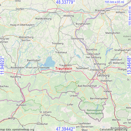
Traunstein GPS coordinates[2]
47° 52' 5.7" North, 12° 38' 36.06" East
| Map corner | latitude | longitude |
|---|---|---|
| Upper-left | 48.33779°, | 11.94023° |
| Center: | 47.86825°, | 12.64335° |
| Lower-right: | 47.39442°, | 13.34648° |
| Map W x H: | 104.9×104.9 km | = 65.2×65.2mi |
| max Lat: | 55.01917° ⇑97% North |
| Traunstein: | 47.86825° |
| min Lat: | ⇓3% South 47.40724° |
| min Long | Traunstein | max Long |
| 5.92978° | 12.64335° | 14.98853° |
| W 89.3%⇐ | ⇒10.7% E |
Elevation
Elevation of Traunstein is 597 m = 1959 ft, and this is 347.9 m = 1141 ft above average elevation for this country.
| Max E: |
1256 m = 4121 ft | 5.1% |
| Traunstein | 597 m 1959 ft | |
| Avg. | 249.1 m = 817 ft | |
Min E: |
-5 m = -16 ft | 94.9% |
See also: Germany elevation on elevation.city.
Geographical zone
Traunstein is located in North temperate zone (between Tropic of Cancer and the Arctic Circle). Distance of this North polar circle is 2078.7 km =1291.6 mi to North.| Distance of | km | miles | from Traunstein |
|---|---|---|---|
| North Pole | 4684.6 | 2910.9 | to North |
| Arctic Circle | 2078.7 | 1291.6 | to North |
| Tropic Cancer | 2716.5 | 1688 | to South |
| Equator | 5322.5 | 3307.2 | to South |


Nearby cities:
15 places around Traunstein: (largest is in red/bold)
• Bergen
7.8 km =4.8 mi,  210°
210°
• Chieming
8.2 km =5.1 mi,  289°
289°
• Grabenstätt
7.9 km =4.9 mi,  251°
251°
• Nußdorf
5.5 km =3.4 mi,  319°
319°
• Petting
13.7 km =8.5 mi,  69°
69°
• Ruhpolding
11.3 km =7 mi,  177°
177°
• Sankt Leonhard am Wonneberg
7.7 km =4.8 mi,  47°
47°
• Siegsdorf
5.1 km =3.2 mi, 180°
• Surberg
4.2 km =2.6 mi,  92°
92°
• Taching am See
12 km =7.5 mi,  32°
32°
• Teisendorf
13.3 km =8.3 mi,  99°
99°
• Traunreut
11.2 km =7 mi,  340°
340°
• Vachendorf
4 km =2.5 mi,  224°
224°
• Waging am See
10 km =6.2 mi,  42°
42°
• Übersee
13.2 km =8.2 mi,  244°
244°
Sources, notices
• [Note1] Compared only with cities in Germany existing in our database
• [Src1] Map data: © OpenStreetMap contributors (CC-BY-SA)
• [Src2] Other city data from geonames.org with taken over terms of usage.
• [Src3] Geographical zone / Annual Mean Temperature by Robert A. Rohde @ Wikipedia
