Siegsdorf geodata
Siegsdorf (Bavaria) is a seat of a fourth-order administrative division; located in Germany in Europe/Berlin (GMT+2) time zone. With population of 8,230 people, there are 1919 cities with bigger population in this country. Compared to other cities in Germany, 97.4% of cities are located further ↑North; 89.3% of cities are located further ←West and 95.3% of cities have lower elevation than Siegsdorf. Note1
Administrative division(s):
- Level 1: Bavaria
- Level 2: Upper Bavaria
- Level 3: Landkreis Traunstein
- Level 4: Siegsdorf


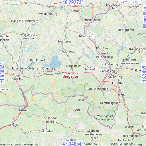
Siegsdorf GPS coordinates[2]
47° 49' 22.008" North, 12° 38' 33.972" East
| Map corner | latitude | longitude |
|---|---|---|
| Upper-left | 48.29273°, | 11.93965° |
| Center: | 47.82278°, | 12.64277° |
| Lower-right: | 47.34854°, | 13.3459° |
| Map W x H: | 105×105 km | = 65.2×65.2mi |
| max Lat: | 55.01917° ⇑97.4% North |
| Siegsdorf: | 47.82278° |
| min Lat: | ⇓2.6% South 47.40724° |
| min Long | Siegsdorf | max Long |
| 5.92978° | 12.64277° | 14.98853° |
| W 89.3%⇐ | ⇒10.7% E |
Elevation
Elevation of Siegsdorf is 605 m = 1985 ft, and this is 355.9 m = 1168 ft above average elevation for this country.
| Max E: |
1256 m = 4121 ft | 4.7% |
| Siegsdorf | 605 m 1985 ft | |
| Avg. | 249.1 m = 817 ft | |
Min E: |
-5 m = -16 ft | 95.3% |
See also: Germany elevation on elevation.city.
Geographical zone
Siegsdorf is located in North temperate zone (between Tropic of Cancer and the Arctic Circle). Distance of this North polar circle is 2083.8 km =1294.8 mi to North.| Distance of | km | miles | from Siegsdorf |
|---|---|---|---|
| North Pole | 4689.7 | 2914 | to North |
| Arctic Circle | 2083.8 | 1294.8 | to North |
| Tropic Cancer | 2711.5 | 1684.8 | to South |
| Equator | 5317.4 | 3304.1 | to South |


Nearby cities:
15 places around Siegsdorf: (largest is in red/bold)
• Bergen
4.3 km =2.7 mi,  247°
247°
• Chieming
10.9 km =6.8 mi,  315°
315°
• Grabenstätt
7.8 km =4.8 mi,  288°
288°
• Grassau
14.9 km =9.3 mi, 251°
• Inzell
10.5 km =6.5 mi,  129°
129°
• Nußdorf
9.8 km =6.1 mi,  339°
339°
• Ruhpolding
6.3 km =3.9 mi,  175°
175°
• Sankt Leonhard am Wonneberg
11.8 km =7.3 mi,  29°
29°
• Staudach-Egerndach
12.7 km =7.9 mi, 249°
• Surberg
6.5 km =4 mi,  41°
41°
• Teisendorf
13.5 km =8.4 mi,  77°
77°
• Traunstein
5.1 km =3.2 mi,  0°
0°
• Vachendorf
3.5 km =2.2 mi,  308°
308°
• Waging am See
14.1 km =8.8 mi, 28°
• Übersee
11.9 km =7.4 mi,  266°
266°
Sources, notices
• [Note1] Compared only with cities in Germany existing in our database
• [Src1] Map data: © OpenStreetMap contributors (CC-BY-SA)
• [Src2] Other city data from geonames.org with taken over terms of usage.
• [Src3] Geographical zone / Annual Mean Temperature by Robert A. Rohde @ Wikipedia
