Palling geodata
Palling (Bavaria) is a seat of a fourth-order administrative division; located in Germany in Europe/Berlin (GMT+2) time zone. With population of 3,416 people, there are 3677 cities with bigger population in this country. Compared to other cities in Germany, 95.5% of cities are located further ↑North; 89.2% of cities are located further ←West and 91.1% of cities have lower elevation than Palling. Note1
Administrative division(s):
- Level 1: Bavaria
- Level 2: Upper Bavaria
- Level 3: Landkreis Traunstein
- Level 4: Palling


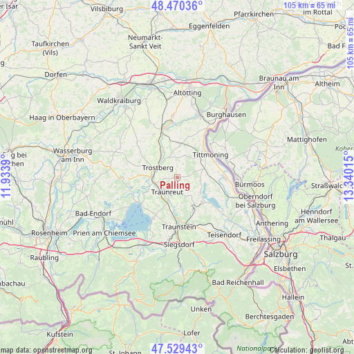
Palling GPS coordinates[2]
48° 0' 7.344" North, 12° 38' 13.272" East
| Map corner | latitude | longitude |
|---|---|---|
| Upper-left | 48.47036°, | 11.9339° |
| Center: | 48.00204°, | 12.63702° |
| Lower-right: | 47.52943°, | 13.34015° |
| Map W x H: | 104.6×104.6 km | = 65×65mi |
| max Lat: | 55.01917° ⇑95.5% North |
| Palling: | 48.00204° |
| min Lat: | ⇓4.5% South 47.40724° |
| min Long | Palling | max Long |
| 5.92978° | 12.63702° | 14.98853° |
| W 89.2%⇐ | ⇒10.8% E |
Elevation
Elevation of Palling is 529 m = 1736 ft, and this is 279.9 m = 918 ft above average elevation for this country.
| Max E: |
1256 m = 4121 ft | 8.9% |
| Palling | 529 m 1736 ft | |
| Avg. | 249.1 m = 817 ft | |
Min E: |
-5 m = -16 ft | 91.1% |
See also: Germany elevation on elevation.city.
Geographical zone
Palling is located in North temperate zone (between Tropic of Cancer and the Arctic Circle). Distance of this North polar circle is 2063.8 km =1282.4 mi to North.| Distance of | km | miles | from Palling |
|---|---|---|---|
| North Pole | 4669.7 | 2901.6 | to North |
| Arctic Circle | 2063.8 | 1282.4 | to North |
| Tropic Cancer | 2731.4 | 1697.2 | to South |
| Equator | 5337.3 | 3316.4 | to South |


Nearby cities:
15 places around Palling: (largest is in red/bold)
• Chieming
14.1 km =8.8 mi,  210°
210°
• Engelsberg
14.5 km =9 mi,  331°
331°
• Fridolfing
14.1 km =8.8 mi,  91°
91°
• Kienberg
13.4 km =8.3 mi,  285°
285°
• Kirchweidach
9.3 km =5.8 mi,  3°
3°
• Nußdorf
11.1 km =6.9 mi,  195°
195°
• Sankt Leonhard am Wonneberg
11.4 km =7.1 mi,  147°
147°
• Seeon-Seebruck
13.3 km =8.3 mi,  252°
252°
• Tacherting
9.8 km =6.1 mi, 329°
• Taching am See
8.3 km =5.2 mi,  124°
124°
• Tittmoning
11.8 km =7.3 mi,  55°
55°
• Traunreut
5.5 km =3.4 mi,  217°
217°
• Trostberg an der Alz
6.5 km =4 mi,  296°
296°
• Tyrlaching
7.5 km =4.7 mi,  17°
17°
• Waging am See
10.4 km =6.5 mi,  136°
136°
Sources, notices
• [Note1] Compared only with cities in Germany existing in our database
• [Src1] Map data: © OpenStreetMap contributors (CC-BY-SA)
• [Src2] Other city data from geonames.org with taken over terms of usage.
• [Src3] Geographical zone / Annual Mean Temperature by Robert A. Rohde @ Wikipedia
