Nortorf geodata
Nortorf (Schleswig-Holstein) is a populated place; located in Germany in Europe/Berlin (GMT+2) time zone. With population of 6,396 people, there are 2334 cities with bigger population in this country. Compared to other cities in Germany, 94.8% of cities are located further ↓South; 52.1% of cities are located further →East and 87% of cities have higher elevation than Nortorf. Note1
Administrative division(s):
- Level 1: Schleswig-Holstein
- Level 3: Kreis Rendsburg-Eckernförde
- Level 4: Nortorf


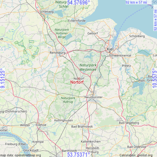
Nortorf GPS coordinates[2]
54° 10' 2.568" North, 9° 51' 15.732" East
| Map corner | latitude | longitude |
|---|---|---|
| Upper-left | 54.57696°, | 9.15125° |
| Center: | 54.16738°, | 9.85437° |
| Lower-right: | 53.75371°, | 10.5575° |
| Map W x H: | 91.5×91.5 km | = 56.9×56.9mi |
| max Lat: | 55.01917° ⇑5.2% North |
| Nortorf: | 54.16738° |
| min Lat: | ⇓94.8% South 47.40724° |
| min Long | Nortorf | max Long |
| 5.92978° | 9.85437° | 14.98853° |
| W 47.9%⇐ | ⇒52.1% E |
Elevation
Elevation of Nortorf is 30 m = 98 ft, and this is 219.1 m = 719 ft below average elevation for this country.
| Max E: |
1256 m = 4121 ft | 87% |
| Avg. | 249.1 m = 817 ft | |
| Nortorf | 30 m = 98 ft | |
Min E: |
-5 m = -16 ft | 13% |
See also: Germany elevation on elevation.city.
Geographical zone
Nortorf is located in North temperate zone (between Tropic of Cancer and the Arctic Circle). Distance of this North polar circle is 1378.3 km =856.4 mi to North.| Distance of | km | miles | from Nortorf |
|---|---|---|---|
| North Pole | 3984.2 | 2475.7 | to North |
| Arctic Circle | 1378.3 | 856.4 | to North |
| Tropic Cancer | 3416.9 | 2123.2 | to South |
| Equator | 6022.8 | 3742.4 | to South |


Nearby cities:
15 places around Nortorf: (largest is in red/bold)
• Bargstedt
5.7 km =3.5 mi,  269°
269°
• Bokel
6.5 km =4 mi,  323°
323°
• Borgdorf-Seedorf
1.9 km =1.2 mi,  92°
92°
• Brammer
6.8 km =4.2 mi,  302°
302°
• Dätgen
5.4 km =3.4 mi,  70°
70°
• Eisendorf
3.7 km =2.3 mi,  12°
12°
• Ellerdorf
3.1 km =1.9 mi,  341°
341°
• Gnutz
4.5 km =2.8 mi,  212°
212°
• Groß Vollstedt
7.4 km =4.6 mi, 6°
• Krogaspe
6.4 km =4 mi,  126°
126°
• Langwedel
6.7 km =4.2 mi,  44°
44°
• Loop
6.5 km =4 mi,  107°
107°
• Schönbek
7.3 km =4.5 mi, 90°
• Timmaspe
4 km =2.5 mi,  139°
139°
• Warder
5.8 km =3.6 mi,  18°
18°
Sources, notices
• [Note1] Compared only with cities in Germany existing in our database
• [Src1] Map data: © OpenStreetMap contributors (CC-BY-SA)
• [Src2] Other city data from geonames.org with taken over terms of usage.
• [Src3] Geographical zone / Annual Mean Temperature by Robert A. Rohde @ Wikipedia
