Eisendorf geodata
Eisendorf (Schleswig-Holstein) is a seat of a fourth-order administrative division; located in Germany in Europe/Berlin (GMT+2) time zone. With population of 294 people, there are 10077 cities with bigger population in this country. Compared to other cities in Germany, 95.1% of cities are located further ↓South; 52% of cities are located further →East and 88.6% of cities have higher elevation than Eisendorf. Note1
Administrative division(s):
- Level 1: Schleswig-Holstein
- Level 3: Kreis Rendsburg-Eckernförde
- Level 4: Eisendorf


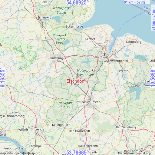
Eisendorf GPS coordinates[2]
54° 12' 0" North, 9° 52' 0.012" East
| Map corner | latitude | longitude |
|---|---|---|
| Upper-left | 54.60925°, | 9.16355° |
| Center: | 54.2°, | 9.86667° |
| Lower-right: | 53.78665°, | 10.5698° |
| Map W x H: | 91.5×91.5 km | = 56.9×56.9mi |
| max Lat: | 55.01917° ⇑4.9% North |
| Eisendorf: | 54.2° |
| min Lat: | ⇓95.1% South 47.40724° |
| min Long | Eisendorf | max Long |
| 5.92978° | 9.86667° | 14.98853° |
| W 48%⇐ | ⇒52% E |
Elevation
Elevation of Eisendorf is 25 m = 82 ft, and this is 224.1 m = 735 ft below average elevation for this country.
| Max E: |
1256 m = 4121 ft | 88.6% |
| Avg. | 249.1 m = 817 ft | |
| Eisendorf | 25 m = 82 ft | |
Min E: |
-5 m = -16 ft | 11.4% |
See also: Germany elevation on elevation.city.
Geographical zone
Eisendorf is located in North temperate zone (between Tropic of Cancer and the Arctic Circle). Distance of this North polar circle is 1374.7 km =854.2 mi to North.| Distance of | km | miles | from Eisendorf |
|---|---|---|---|
| North Pole | 3980.6 | 2473.4 | to North |
| Arctic Circle | 1374.7 | 854.2 | to North |
| Tropic Cancer | 3420.6 | 2125.5 | to South |
| Equator | 6026.5 | 3744.7 | to South |


Nearby cities:
15 places around Eisendorf: (largest is in red/bold)
• Bargstedt
7.5 km =4.7 mi,  240°
240°
• Bokel
4.9 km =3 mi,  288°
288°
• Borgdorf-Seedorf
3.9 km =2.4 mi,  163°
163°
• Brammer
6.5 km =4 mi,  270°
270°
• Dätgen
4.7 km =2.9 mi,  113°
113°
• Ellerdorf
1.9 km =1.2 mi,  248°
248°
• Emkendorf
7.5 km =4.7 mi,  351°
351°
• Gnutz
8.1 km =5 mi,  203°
203°
• Groß Vollstedt
3.7 km =2.3 mi,  0°
0°
• Langwedel
4.1 km =2.5 mi,  73°
73°
• Loop
7.8 km =4.8 mi,  135°
135°
• Nortorf
3.7 km =2.3 mi,  192°
192°
• Schönbek
7.5 km =4.7 mi,  119°
119°
• Timmaspe
6.9 km =4.3 mi, 164°
• Warder
2.1 km =1.3 mi,  30°
30°
Sources, notices
• [Note1] Compared only with cities in Germany existing in our database
• [Src1] Map data: © OpenStreetMap contributors (CC-BY-SA)
• [Src2] Other city data from geonames.org with taken over terms of usage.
• [Src3] Geographical zone / Annual Mean Temperature by Robert A. Rohde @ Wikipedia
