Bargstedt geodata
Bargstedt (Schleswig-Holstein) is a seat of a fourth-order administrative division; located in Germany in Europe/Berlin (GMT+2) time zone. With population of 777 people, there are 7996 cities with bigger population in this country. Compared to other cities in Germany, 94.6% of cities are located further ↓South; 53.4% of cities are located further →East and 90.9% of cities have higher elevation than Bargstedt. Note1
Administrative division(s):
- Level 1: Schleswig-Holstein
- Level 3: Kreis Rendsburg-Eckernförde
- Level 4: Bargstedt


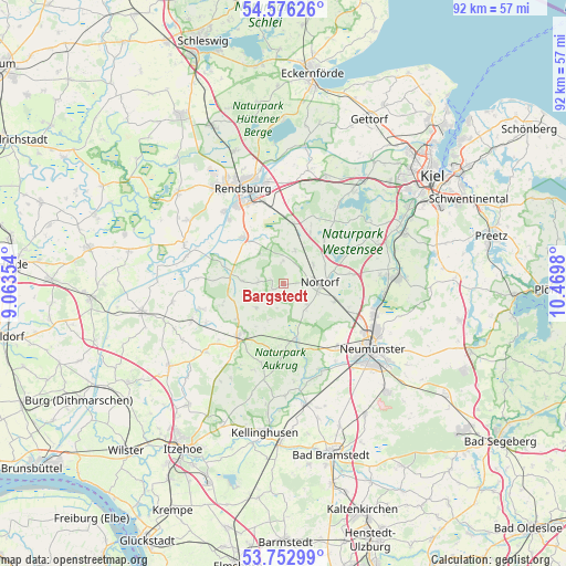
Bargstedt GPS coordinates[2]
54° 10' 0.012" North, 9° 46' 0.012" East
| Map corner | latitude | longitude |
|---|---|---|
| Upper-left | 54.57626°, | 9.06354° |
| Center: | 54.16667°, | 9.76667° |
| Lower-right: | 53.75299°, | 10.4698° |
| Map W x H: | 91.5×91.5 km | = 56.9×56.9mi |
| max Lat: | 55.01917° ⇑5.4% North |
| Bargstedt: | 54.16667° |
| min Lat: | ⇓94.6% South 47.40724° |
| min Long | Bargstedt | max Long |
| 5.92978° | 9.76667° | 14.98853° |
| W 46.6%⇐ | ⇒53.4% E |
Elevation
Elevation of Bargstedt is 19 m = 62 ft, and this is 230.1 m = 755 ft below average elevation for this country.
| Max E: |
1256 m = 4121 ft | 90.9% |
| Avg. | 249.1 m = 817 ft | |
| Bargstedt | 19 m = 62 ft | |
Min E: |
-5 m = -16 ft | 9.1% |
See also: Germany elevation on elevation.city.
Geographical zone
Bargstedt is located in North temperate zone (between Tropic of Cancer and the Arctic Circle). Distance of this North polar circle is 1378.4 km =856.5 mi to North.| Distance of | km | miles | from Bargstedt |
|---|---|---|---|
| North Pole | 3984.3 | 2475.7 | to North |
| Arctic Circle | 1378.4 | 856.5 | to North |
| Tropic Cancer | 3416.9 | 2123.2 | to South |
| Equator | 6022.8 | 3742.4 | to South |


Nearby cities:
15 places around Bargstedt: (largest is in red/bold)
• Bokel
5.6 km =3.5 mi,  19°
19°
• Borgdorf-Seedorf
7.6 km =4.7 mi,  90°
90°
• Brammer
3.7 km =2.3 mi,  0°
0°
• Brinjahe
8.7 km =5.4 mi,  270°
270°
• Eisendorf
7.5 km =4.7 mi,  60°
60°
• Ellerdorf
5.6 km =3.5 mi, 57°
• Gnutz
4.9 km =3 mi,  138°
138°
• Heinkenborstel
3.9 km =2.4 mi,  196°
196°
• Luhnstedt
4.3 km =2.7 mi, 270°
• Mörel
6 km =3.7 mi, 201°
• Nindorf
5.7 km =3.5 mi,  229°
229°
• Nortorf
5.7 km =3.5 mi, 89°
• Oldenhütten
2.9 km =1.8 mi, 229°
• Stafstedt
6.5 km =4 mi, 270°
• Tappendorf
8.4 km =5.2 mi,  214°
214°
Sources, notices
• [Note1] Compared only with cities in Germany existing in our database
• [Src1] Map data: © OpenStreetMap contributors (CC-BY-SA)
• [Src2] Other city data from geonames.org with taken over terms of usage.
• [Src3] Geographical zone / Annual Mean Temperature by Robert A. Rohde @ Wikipedia
