Ellerdorf geodata
Ellerdorf (Schleswig-Holstein) is a seat of a fourth-order administrative division; located in Germany in Europe/Berlin (GMT+2) time zone. With population of 577 people, there are 8939 cities with bigger population in this country. Compared to other cities in Germany, 95% of cities are located further ↓South; 52.3% of cities are located further →East and 90.5% of cities have higher elevation than Ellerdorf. Note1
Administrative division(s):
- Level 1: Schleswig-Holstein
- Level 3: Kreis Rendsburg-Eckernförde
- Level 4: Ellerdorf


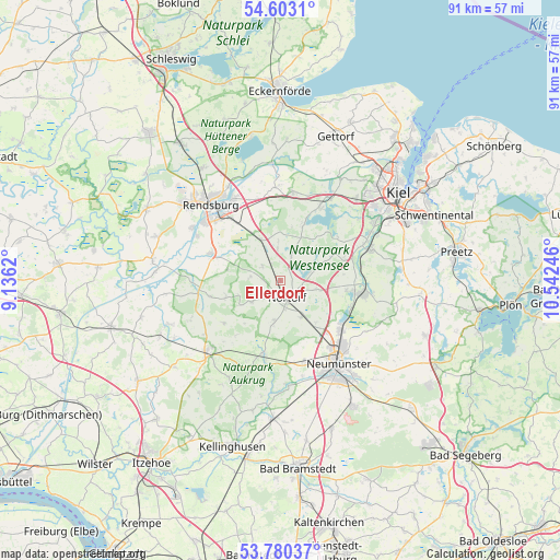
Ellerdorf GPS coordinates[2]
54° 11' 37.608" North, 9° 50' 21.588" East
| Map corner | latitude | longitude |
|---|---|---|
| Upper-left | 54.6031°, | 9.1362° |
| Center: | 54.19378°, | 9.83933° |
| Lower-right: | 53.78037°, | 10.54246° |
| Map W x H: | 91.5×91.5 km | = 56.9×56.9mi |
| max Lat: | 55.01917° ⇑5% North |
| Ellerdorf: | 54.19378° |
| min Lat: | ⇓95% South 47.40724° |
| min Long | Ellerdorf | max Long |
| 5.92978° | 9.83933° | 14.98853° |
| W 47.7%⇐ | ⇒52.3% E |
Elevation
Elevation of Ellerdorf is 20 m = 66 ft, and this is 229.1 m = 752 ft below average elevation for this country.
| Max E: |
1256 m = 4121 ft | 90.5% |
| Avg. | 249.1 m = 817 ft | |
| Ellerdorf | 20 m = 66 ft | |
Min E: |
-5 m = -16 ft | 9.5% |
See also: Germany elevation on elevation.city.
Geographical zone
Ellerdorf is located in North temperate zone (between Tropic of Cancer and the Arctic Circle). Distance of this North polar circle is 1375.4 km =854.6 mi to North.| Distance of | km | miles | from Ellerdorf |
|---|---|---|---|
| North Pole | 3981.3 | 2473.9 | to North |
| Arctic Circle | 1375.4 | 854.6 | to North |
| Tropic Cancer | 3419.9 | 2125 | to South |
| Equator | 6025.8 | 3744.3 | to South |


Nearby cities:
15 places around Ellerdorf: (largest is in red/bold)
• Bargstedt
5.6 km =3.5 mi,  237°
237°
• Bokel
3.6 km =2.2 mi,  308°
308°
• Borgdorf-Seedorf
4.2 km =2.6 mi,  136°
136°
• Brammer
4.8 km =3 mi,  278°
278°
• Dätgen
6.2 km =3.9 mi,  100°
100°
• Eisendorf
1.9 km =1.2 mi,  68°
68°
• Emkendorf
8.1 km =5 mi,  4°
4°
• Gnutz
6.9 km =4.3 mi,  192°
192°
• Groß Vollstedt
4.7 km =2.9 mi,  22°
22°
• Langwedel
6 km =3.7 mi, 72°
• Loop
8.7 km =5.4 mi,  124°
124°
• Nortorf
3.1 km =1.9 mi,  161°
161°
• Oldenhütten
8.4 km =5.2 mi,  234°
234°
• Timmaspe
7 km =4.3 mi,  149°
149°
• Warder
3.8 km =2.4 mi,  48°
48°
Sources, notices
• [Note1] Compared only with cities in Germany existing in our database
• [Src1] Map data: © OpenStreetMap contributors (CC-BY-SA)
• [Src2] Other city data from geonames.org with taken over terms of usage.
• [Src3] Geographical zone / Annual Mean Temperature by Robert A. Rohde @ Wikipedia
