Norderstedt geodata
Norderstedt (Schleswig-Holstein) is a populated place; located in Germany in Europe/Berlin (GMT+2) time zone. With population of 71,439 people, there are 145 cities with bigger population in this country. Compared to other cities in Germany, 88.4% of cities are located further ↓South; 50.3% of cities are located further →East and 87.3% of cities have higher elevation than Norderstedt. Note1
Administrative division(s):
- Level 1: Schleswig-Holstein
- Level 3: Kreis Segeberg
- Level 4: Norderstedt


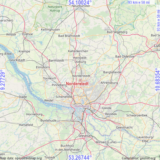
Norderstedt GPS coordinates[2]
53° 41' 9.24" North, 9° 58' 49.476" East
| Map corner | latitude | longitude |
|---|---|---|
| Upper-left | 54.10024°, | 9.27729° |
| Center: | 53.6859°, | 9.98041° |
| Lower-right: | 53.26744°, | 10.68354° |
| Map W x H: | 92.6×92.6 km | = 57.5×57.5mi |
| max Lat: | 55.01917° ⇑11.6% North |
| Norderstedt: | 53.6859° |
| min Lat: | ⇓88.4% South 47.40724° |
| min Long | Norderstedt | max Long |
| 5.92978° | 9.98041° | 14.98853° |
| W 49.7%⇐ | ⇒50.3% E |
Elevation
Elevation of Norderstedt is 29 m = 95 ft, and this is 220.1 m = 722 ft below average elevation for this country.
| Max E: |
1256 m = 4121 ft | 87.3% |
| Avg. | 249.1 m = 817 ft | |
| Norderstedt | 29 m = 95 ft | |
Min E: |
-5 m = -16 ft | 12.7% |
See also: Norderstedt elevation on elevation.city.
Geographical zone
Norderstedt is located in North temperate zone (between Tropic of Cancer and the Arctic Circle). Distance of this North polar circle is 1431.9 km =889.7 mi to North.| Distance of | km | miles | from Norderstedt |
|---|---|---|---|
| North Pole | 4037.7 | 2508.9 | to North |
| Arctic Circle | 1431.9 | 889.7 | to North |
| Tropic Cancer | 3363.4 | 2089.9 | to South |
| Equator | 5969.3 | 3709.1 | to South |


Nearby cities:
15 places around Norderstedt: (largest is in red/bold)
• Alsterdorf
8.6 km =5.3 mi,  165°
165°
• Bönningstedt
4.7 km =2.9 mi,  243°
243°
• Duvenstedt
8.5 km =5.3 mi,  73°
73°
• Ellerau
8.3 km =5.2 mi,  329°
329°
• Ellerbek
7.9 km =4.9 mi,  247°
247°
• Fuhlsbüttel
6.2 km =3.9 mi,  157°
157°
• Hasloh
4.3 km =2.7 mi,  283°
283°
• Hummelsbüttel
5.8 km =3.6 mi,  136°
136°
• Langenhorn
3.2 km =2 mi,  131°
131°
• Lemsahl-Mellingstedt
7.7 km =4.8 mi,  86°
86°
• Ohlsdorf
7.5 km =4.7 mi,  153°
153°
• Poppenbüttel
7.5 km =4.7 mi,  113°
113°
• Quickborn
6.6 km =4.1 mi,  315°
315°
• Tangstedt
8.6 km =5.3 mi,  52°
52°
• Wellingsbüttel
8.2 km =5.1 mi, 127°
Sources, notices
• [Note1] Compared only with cities in Germany existing in our database
• [Src1] Map data: © OpenStreetMap contributors (CC-BY-SA)
• [Src2] Other city data from geonames.org with taken over terms of usage.
• [Src3] Geographical zone / Annual Mean Temperature by Robert A. Rohde @ Wikipedia
