Norath geodata
Norath (Rheinland-Pfalz) is a seat of a fourth-order administrative division; located in Germany in Europe/Berlin (GMT+2) time zone. With population of 445 people, there are 9556 cities with bigger population in this country. Compared to other cities in Germany, 60.7% of cities are located further ↑North; 85.4% of cities are located further →East and 85.3% of cities have lower elevation than Norath. Note1


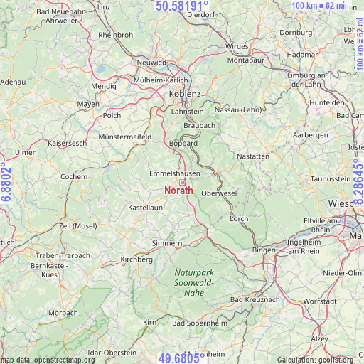
Norath GPS coordinates[2]
50° 7' 59.988" North, 7° 34' 59.988" East
| Map corner | latitude | longitude |
|---|---|---|
| Upper-left | 50.58191°, | 6.8802° |
| Center: | 50.13333°, | 7.58333° |
| Lower-right: | 49.6805°, | 8.28645° |
| Map W x H: | 100.2×100.2 km | = 62.3×62.3mi |
| max Lat: | 55.01917° ⇑60.7% North |
| Norath: | 50.13333° |
| min Lat: | ⇓39.3% South 47.40724° |
| min Long | Norath | max Long |
| 5.92978° | 7.58333° | 14.98853° |
| W 14.6%⇐ | ⇒85.4% E |
Elevation
Elevation of Norath is 472 m = 1549 ft, and this is 222.9 m = 731 ft above average elevation for this country.
| Max E: |
1256 m = 4121 ft | 14.7% |
| Norath | 472 m 1549 ft | |
| Avg. | 249.1 m = 817 ft | |
Min E: |
-5 m = -16 ft | 85.3% |
See also: Germany elevation on elevation.city.
Geographical zone
Norath is located in North temperate zone (between Tropic of Cancer and the Arctic Circle). Distance of this North polar circle is 1826.9 km =1135.2 mi to North.| Distance of | km | miles | from Norath |
|---|---|---|---|
| North Pole | 4432.8 | 2754.4 | to North |
| Arctic Circle | 1826.9 | 1135.2 | to North |
| Tropic Cancer | 2968.4 | 1844.5 | to South |
| Equator | 5574.3 | 3463.7 | to South |


Nearby cities:
15 places around Norath: (largest is in red/bold)
• Badenhard
4 km =2.5 mi,  117°
117°
• Bickenbach
4 km =2.5 mi,  257°
257°
• Birkheim
3 km =1.9 mi,  127°
127°
• Dörth
1.9 km =1.2 mi,  0°
0°
• Emmelshausen
3.3 km =2.1 mi,  316°
316°
• Hausbay
3.4 km =2.1 mi,  210°
210°
• Hungenroth
1.2 km =0.7 mi,  90°
90°
• Karbach
3 km =1.9 mi,  52°
52°
• Leiningen
1.2 km =0.7 mi,  270°
270°
• Mühlpfad
2.4 km =1.5 mi,  235°
235°
• Niedert
3.6 km =2.2 mi, 270°
• Pfalzfeld
2.4 km =1.5 mi,  188°
188°
• Schwall
3 km =1.9 mi,  307°
307°
• Thörlingen
3.6 km =2.2 mi, 270°
• Utzenhain
3.6 km =2.2 mi, 90°
Sources, notices
• [Note1] Compared only with cities in Germany existing in our database
• [Src1] Map data: © OpenStreetMap contributors (CC-BY-SA)
• [Src2] Other city data from geonames.org with taken over terms of usage.
• [Src3] Geographical zone / Annual Mean Temperature by Robert A. Rohde @ Wikipedia
