Nievern geodata
Nievern (Rheinland-Pfalz) is a seat of a fourth-order administrative division; located in Germany in Europe/Berlin (GMT+2) time zone. With population of 982 people, there are 7245 cities with bigger population in this country. Compared to other cities in Germany, 56.1% of cities are located further ↑North; 83.4% of cities are located further →East and 55.4% of cities have higher elevation than Nievern. Note1


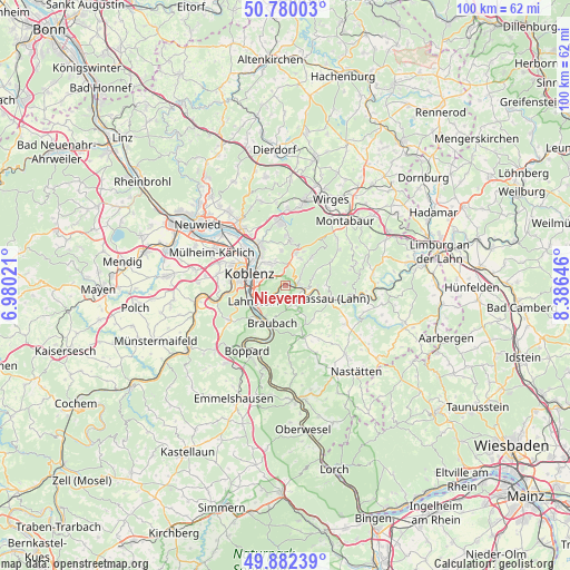
Nievern GPS coordinates[2]
50° 19' 59.988" North, 7° 40' 59.988" East
| Map corner | latitude | longitude |
|---|---|---|
| Upper-left | 50.78003°, | 6.98021° |
| Center: | 50.33333°, | 7.68333° |
| Lower-right: | 49.88239°, | 8.38646° |
| Map W x H: | 99.8×99.8 km | = 62×62mi |
| max Lat: | 55.01917° ⇑56.1% North |
| Nievern: | 50.33333° |
| min Lat: | ⇓43.9% South 47.40724° |
| min Long | Nievern | max Long |
| 5.92978° | 7.68333° | 14.98853° |
| W 16.6%⇐ | ⇒83.4% E |
Elevation
Elevation of Nievern is 186 m = 610 ft, and this is 63.1 m = 207 ft below average elevation for this country.
| Max E: |
1256 m = 4121 ft | 55.4% |
| Avg. | 249.1 m = 817 ft | |
| Nievern | 186 m = 610 ft | |
Min E: |
-5 m = -16 ft | 44.6% |
See also: Germany elevation on elevation.city.
Geographical zone
Nievern is located in North temperate zone (between Tropic of Cancer and the Arctic Circle). Distance of this North polar circle is 1804.6 km =1121.3 mi to North.| Distance of | km | miles | from Nievern |
|---|---|---|---|
| North Pole | 4410.5 | 2740.6 | to North |
| Arctic Circle | 1804.6 | 1121.3 | to North |
| Tropic Cancer | 2990.6 | 1858.3 | to South |
| Equator | 5596.5 | 3477.5 | to South |


Nearby cities:
15 places around Nievern: (largest is in red/bold)
• Bad Ems
2.2 km =1.4 mi,  83°
83°
• Becheln
5.1 km =3.2 mi,  151°
151°
• Dausenau
5.9 km =3.7 mi,  90°
90°
• Eitelborn
5.7 km =3.5 mi,  29°
29°
• Fachbach
0 km =0 mi,  0°
0°
• Frücht
1.9 km =1.2 mi,  180°
180°
• Kadenbach
6.6 km =4.1 mi, 32°
• Kemmenau
5.1 km =3.2 mi,  68°
68°
• Lahnstein
6 km =3.7 mi,  231°
231°
• Miellen
1.2 km =0.7 mi,  270°
270°
• Misselberg
6.8 km =4.2 mi,  115°
115°
• Neuhäusel
5.9 km =3.7 mi,  18°
18°
• Simmern
6.2 km =3.9 mi,  353°
353°
• Sulzbach
6 km =3.7 mi, 124°
• Urbar
6.6 km =4.1 mi,  327°
327°
Sources, notices
• [Note1] Compared only with cities in Germany existing in our database
• [Src1] Map data: © OpenStreetMap contributors (CC-BY-SA)
• [Src2] Other city data from geonames.org with taken over terms of usage.
• [Src3] Geographical zone / Annual Mean Temperature by Robert A. Rohde @ Wikipedia
