Kemmenau geodata
Kemmenau (Rheinland-Pfalz) is a seat of a fourth-order administrative division; located in Germany in Europe/Berlin (GMT+2) time zone. With population of 502 people, there are 9363 cities with bigger population in this country. Compared to other cities in Germany, 55.7% of cities are located further ↑North; 82.1% of cities are located further →East and 80.1% of cities have lower elevation than Kemmenau. Note1


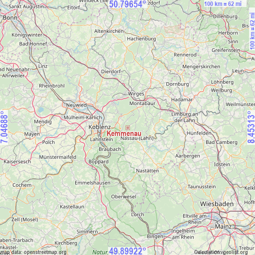
Kemmenau GPS coordinates[2]
50° 21' 0" North, 7° 45' 0" East
| Map corner | latitude | longitude |
|---|---|---|
| Upper-left | 50.79654°, | 7.04688° |
| Center: | 50.35°, | 7.75° |
| Lower-right: | 49.89922°, | 8.45313° |
| Map W x H: | 99.8×99.8 km | = 62×62mi |
| max Lat: | 55.01917° ⇑55.7% North |
| Kemmenau: | 50.35° |
| min Lat: | ⇓44.3% South 47.40724° |
| min Long | Kemmenau | max Long |
| 5.92978° | 7.75° | 14.98853° |
| W 17.9%⇐ | ⇒82.1% E |
Elevation
Elevation of Kemmenau is 433 m = 1421 ft, and this is 183.9 m = 603 ft above average elevation for this country.
| Max E: |
1256 m = 4121 ft | 19.9% |
| Kemmenau | 433 m 1421 ft | |
| Avg. | 249.1 m = 817 ft | |
Min E: |
-5 m = -16 ft | 80.1% |
See also: Germany elevation on elevation.city.
Geographical zone
Kemmenau is located in North temperate zone (between Tropic of Cancer and the Arctic Circle). Distance of this North polar circle is 1802.8 km =1120.2 mi to North.| Distance of | km | miles | from Kemmenau |
|---|---|---|---|
| North Pole | 4408.7 | 2739.4 | to North |
| Arctic Circle | 1802.8 | 1120.2 | to North |
| Tropic Cancer | 2992.5 | 1859.5 | to South |
| Equator | 5598.4 | 3478.7 | to South |


Nearby cities:
15 places around Kemmenau: (largest is in red/bold)
• Arzbach
3.2 km =2 mi,  359°
359°
• Bad Ems
3 km =1.9 mi,  237°
237°
• Dausenau
2.2 km =1.4 mi,  147°
147°
• Dienethal
5.5 km =3.4 mi,  159°
159°
• Eitelborn
3.6 km =2.2 mi,  328°
328°
• Fachbach
5.1 km =3.2 mi,  248°
248°
• Hömberg
3 km =1.9 mi,  128°
128°
• Kadenbach
3.9 km =2.4 mi,  342°
342°
• Misselberg
5 km =3.1 mi, 163°
• Nassau
5.3 km =3.3 mi,  137°
137°
• Neuhäusel
4.7 km =2.9 mi,  322°
322°
• Nievern
5.1 km =3.2 mi, 248°
• Sulzbach
5.3 km =3.3 mi,  178°
178°
• Welschneudorf
4.3 km =2.7 mi,  52°
52°
• Zimmerschied
2.4 km =1.5 mi,  90°
90°
Sources, notices
• [Note1] Compared only with cities in Germany existing in our database
• [Src1] Map data: © OpenStreetMap contributors (CC-BY-SA)
• [Src2] Other city data from geonames.org with taken over terms of usage.
• [Src3] Geographical zone / Annual Mean Temperature by Robert A. Rohde @ Wikipedia
