Nienburg/Saale geodata
Nienburg/Saale (Saxony-Anhalt) is a populated place; located in Germany in Europe/Berlin (GMT+2) time zone. With population of 4,527 people, there are 3025 cities with bigger population in this country. Compared to other cities in Germany, 70.4% of cities are located further ↓South; 78.4% of cities are located further ←West and 73.6% of cities have higher elevation than Nienburg/Saale. Note1


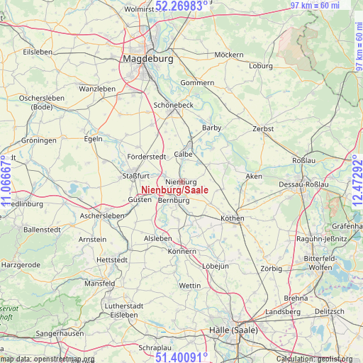
Nienburg/Saale GPS coordinates[2]
51° 50' 14.892" North, 11° 46' 11.244" East
| Map corner | latitude | longitude |
|---|---|---|
| Upper-left | 52.26983°, | 11.06667° |
| Center: | 51.83747°, | 11.76979° |
| Lower-right: | 51.40091°, | 12.47292° |
| Map W x H: | 96.6×96.6 km | = 60×60mi |
| max Lat: | 55.01917° ⇑29.6% North |
| Nienburg/Saale: | 51.83747° |
| min Lat: | ⇓70.4% South 47.40724° |
| min Long | Nienburg/Saale | max Long |
| 5.92978° | 11.76979° | 14.98853° |
| W 78.4%⇐ | ⇒21.6% E |
Elevation
Elevation of Nienburg/Saale is 69 m = 226 ft, and this is 180.1 m = 591 ft below average elevation for this country.
| Max E: |
1256 m = 4121 ft | 73.6% |
| Avg. | 249.1 m = 817 ft | |
| Nienburg/Saale | 69 m = 226 ft | |
Min E: |
-5 m = -16 ft | 26.4% |
See also: Germany elevation on elevation.city.
Geographical zone
Nienburg/Saale is located in North temperate zone (between Tropic of Cancer and the Arctic Circle). Distance of this North polar circle is 1637.4 km =1017.4 mi to North.| Distance of | km | miles | from Nienburg/Saale |
|---|---|---|---|
| North Pole | 4243.3 | 2636.7 | to North |
| Arctic Circle | 1637.4 | 1017.4 | to North |
| Tropic Cancer | 3157.9 | 1962.2 | to South |
| Equator | 5763.8 | 3581.5 | to South |


Nearby cities:
15 places around Nienburg/Saale: (largest is in red/bold)
• Baalberge
8.3 km =5.2 mi,  166°
166°
• Bernburg
5.2 km =3.2 mi,  203°
203°
• Brumby
7.5 km =4.7 mi,  331°
331°
• Calbe
7.7 km =4.8 mi,  2°
2°
• Drosa
9.6 km =6 mi,  104°
104°
• Gerbitz
3.9 km =2.4 mi,  82°
82°
• Glöthe
10.4 km =6.5 mi,  321°
321°
• Gröna
9.5 km =5.9 mi,  211°
211°
• Ilberstedt
8.2 km =5.1 mi,  239°
239°
• Kleinpaschleben
9.9 km =6.2 mi,  127°
127°
• Latdorf
3.8 km =2.4 mi,  146°
146°
• Neugattersleben
4.5 km =2.8 mi,  289°
289°
• Poley
7.7 km =4.8 mi, 153°
• Rathmannsdorf
10 km =6.2 mi,  259°
259°
• Wohlsdorf
10.4 km =6.5 mi,  141°
141°
Sources, notices
• [Note1] Compared only with cities in Germany existing in our database
• [Src1] Map data: © OpenStreetMap contributors (CC-BY-SA)
• [Src2] Other city data from geonames.org with taken over terms of usage.
• [Src3] Geographical zone / Annual Mean Temperature by Robert A. Rohde @ Wikipedia
