Latdorf geodata
Latdorf (Saxony-Anhalt) is a populated place; located in Germany in Europe/Berlin (GMT+2) time zone. With population of 802 people, there are 7889 cities with bigger population in this country. Compared to other cities in Germany, 70% of cities are located further ↓South; 78.8% of cities are located further ←West and 72.8% of cities have higher elevation than Latdorf. Note1


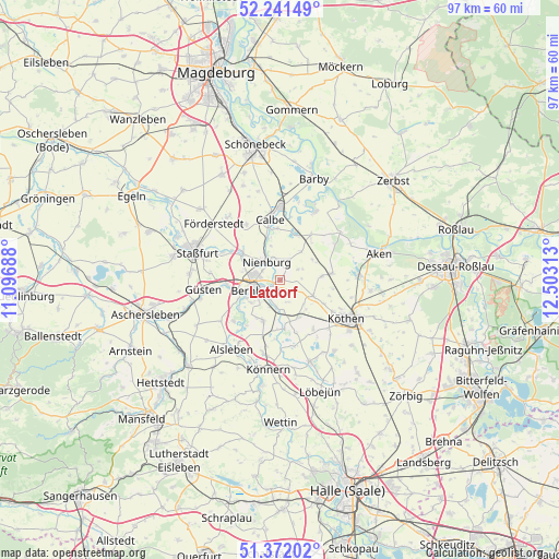
Latdorf GPS coordinates[2]
51° 48' 31.86" North, 11° 48' 0" East
| Map corner | latitude | longitude |
|---|---|---|
| Upper-left | 52.24149°, | 11.09688° |
| Center: | 51.80885°, | 11.8° |
| Lower-right: | 51.37202°, | 12.50313° |
| Map W x H: | 96.7×96.7 km | = 60.1×60.1mi |
| max Lat: | 55.01917° ⇑30% North |
| Latdorf: | 51.80885° |
| min Lat: | ⇓70% South 47.40724° |
| min Long | Latdorf | max Long |
| 5.92978° | 11.8° | 14.98853° |
| W 78.8%⇐ | ⇒21.2% E |
Elevation
Elevation of Latdorf is 73 m = 240 ft, and this is 176.1 m = 578 ft below average elevation for this country.
| Max E: |
1256 m = 4121 ft | 72.8% |
| Avg. | 249.1 m = 817 ft | |
| Latdorf | 73 m = 240 ft | |
Min E: |
-5 m = -16 ft | 27.2% |
See also: Germany elevation on elevation.city.
Geographical zone
Latdorf is located in North temperate zone (between Tropic of Cancer and the Arctic Circle). Distance of this North polar circle is 1640.6 km =1019.4 mi to North.| Distance of | km | miles | from Latdorf |
|---|---|---|---|
| North Pole | 4246.5 | 2638.7 | to North |
| Arctic Circle | 1640.6 | 1019.4 | to North |
| Tropic Cancer | 3154.7 | 1960.2 | to South |
| Equator | 5760.6 | 3579.5 | to South |


Nearby cities:
15 places around Latdorf: (largest is in red/bold)
• Baalberge
4.9 km =3 mi,  180°
180°
• Bernburg
4.4 km =2.7 mi,  249°
249°
• Biendorf
7.3 km =4.5 mi,  152°
152°
• Drosa
7.3 km =4.5 mi,  83°
83°
• Gerbitz
4.1 km =2.5 mi,  25°
25°
• Gröna
8.6 km =5.3 mi,  235°
235°
• Kleinpaschleben
6.4 km =4 mi,  115°
115°
• Neugattersleben
7.9 km =4.9 mi,  306°
306°
• Nienburg/Saale
3.8 km =2.4 mi,  326°
326°
• Peißen
7.8 km =4.8 mi,  201°
201°
• Poley
4 km =2.5 mi,  158°
158°
• Preußlitz
8.5 km =5.3 mi,  174°
174°
• Wohlsdorf
6.7 km =4.2 mi,  137°
137°
• Wulfen
9.1 km =5.7 mi, 82°
• Zabitz
8.9 km =5.5 mi,  107°
107°
Sources, notices
• [Note1] Compared only with cities in Germany existing in our database
• [Src1] Map data: © OpenStreetMap contributors (CC-BY-SA)
• [Src2] Other city data from geonames.org with taken over terms of usage.
• [Src3] Geographical zone / Annual Mean Temperature by Robert A. Rohde @ Wikipedia
