Niederschlettenbach geodata
Niederschlettenbach (Rheinland-Pfalz) is a seat of a fourth-order administrative division; located in Germany in Europe/Berlin (GMT+2) time zone. With population of 376 people, there are 9770 cities with bigger population in this country. Compared to other cities in Germany, 82% of cities are located further ↑North; 80.1% of cities are located further →East and 55.8% of cities have higher elevation than Niederschlettenbach. Note1
Administrative division(s):
- Level 1: Rheinland-Pfalz
- Level 3: Südwestpfalz
- Level 4: Niederschlettenbach


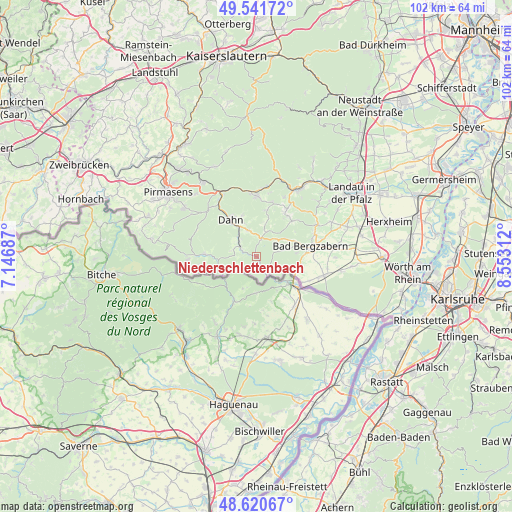
Niederschlettenbach GPS coordinates[2]
49° 4' 59.988" North, 7° 51' 0" East
| Map corner | latitude | longitude |
|---|---|---|
| Upper-left | 49.54172°, | 7.14687° |
| Center: | 49.08333°, | 7.85° |
| Lower-right: | 48.62067°, | 8.55312° |
| Map W x H: | 102.4×102.4 km | = 63.6×63.6mi |
| max Lat: | 55.01917° ⇑82% North |
| Niederschlettenbach: | 49.08333° |
| min Lat: | ⇓18% South 47.40724° |
| min Long | Niederschletten | max Long |
| 5.92978° | 7.85° | 14.98853° |
| W 19.9%⇐ | ⇒80.1% E |
Elevation
Elevation of Niederschlettenbach is 183 m = 600 ft, and this is 66.1 m = 217 ft below average elevation for this country.
| Max E: |
1256 m = 4121 ft | 55.8% |
| Avg. | 249.1 m = 817 ft | |
| Niederschlettenbach | 183 m = 600 ft | |
Min E: |
-5 m = -16 ft | 44.2% |
See also: Germany elevation on elevation.city.
Geographical zone
Niederschlettenbach is located in North temperate zone (between Tropic of Cancer and the Arctic Circle). Distance of this North polar circle is 1943.6 km =1207.7 mi to North.| Distance of | km | miles | from Niederschlettenbach |
|---|---|---|---|
| North Pole | 4549.5 | 2826.9 | to North |
| Arctic Circle | 1943.6 | 1207.7 | to North |
| Tropic Cancer | 2851.6 | 1771.9 | to South |
| Equator | 5457.6 | 3391.2 | to South |


Nearby cities:
15 places around Niederschlettenbach: (largest is in red/bold)
• Birkenhördt
7.1 km =4.4 mi,  58°
58°
• Bobenthal
2.2 km =1.4 mi,  146°
146°
• Bruchweiler-Bärenbach
5.2 km =3.2 mi,  315°
315°
• Bundenthal
3.3 km =2.1 mi,  294°
294°
• Busenberg
5.4 km =3.4 mi,  343°
343°
• Böllenborn
6.3 km =3.9 mi,  73°
73°
• Darstein
7.8 km =4.8 mi,  18°
18°
• Dörrenbach
8.1 km =5 mi,  84°
84°
• Erfweiler
8.7 km =5.4 mi, 341°
• Nothweiler
4.1 km =2.5 mi,  243°
243°
• Oberschlettenbach
7.2 km =4.5 mi,  12°
12°
• Rumbach
4.8 km =3 mi, 288°
• Schindhard
6.8 km =4.2 mi, 342°
• Schweigen-Rechtenbach
8.4 km =5.2 mi,  113°
113°
• Vorderweidenthal
6.1 km =3.8 mi, 23°
Sources, notices
• [Note1] Compared only with cities in Germany existing in our database
• [Src1] Map data: © OpenStreetMap contributors (CC-BY-SA)
• [Src2] Other city data from geonames.org with taken over terms of usage.
• [Src3] Geographical zone / Annual Mean Temperature by Robert A. Rohde @ Wikipedia
