Bruchweiler-Bärenbach geodata
Bruchweiler-Bärenbach (Rheinland-Pfalz) is a seat of a fourth-order administrative division; located in Germany in Europe/Berlin (GMT+2) time zone. With population of 1,767 people, there are 5400 cities with bigger population in this country. Compared to other cities in Germany, 81.5% of cities are located further ↑North; 81% of cities are located further →East and 53.7% of cities have higher elevation than Bruchweiler-Bärenbach. Note1
Administrative division(s):
- Level 1: Rheinland-Pfalz
- Level 3: Südwestpfalz
- Level 4: Bruchweiler-Bärenbach


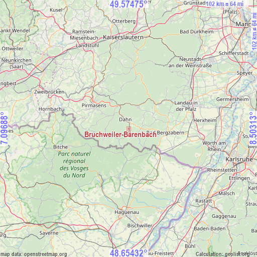
Bruchweiler-Bärenbach GPS coordinates[2]
49° 7' 0.012" North, 7° 48' 0" East
| Map corner | latitude | longitude |
|---|---|---|
| Upper-left | 49.57475°, | 7.09688° |
| Center: | 49.11667°, | 7.8° |
| Lower-right: | 48.65432°, | 8.50313° |
| Map W x H: | 102.3×102.3 km | = 63.6×63.6mi |
| max Lat: | 55.01917° ⇑81.5% North |
| Bruchweiler-Bärenbach: | 49.11667° |
| min Lat: | ⇓18.5% South 47.40724° |
| min Long | Bruchweiler-Bä | max Long |
| 5.92978° | 7.8° | 14.98853° |
| W 19%⇐ | ⇒81% E |
Elevation
Elevation of Bruchweiler-Bärenbach is 199 m = 653 ft, and this is 50.1 m = 164 ft below average elevation for this country.
| Max E: |
1256 m = 4121 ft | 53.7% |
| Avg. | 249.1 m = 817 ft | |
| Bruchweiler-Bärenbach | 199 m = 653 ft | |
Min E: |
-5 m = -16 ft | 46.3% |
See also: Germany elevation on elevation.city.
Geographical zone
Bruchweiler-Bärenbach is located in North temperate zone (between Tropic of Cancer and the Arctic Circle). Distance of this North polar circle is 1939.9 km =1205.4 mi to North.| Distance of | km | miles | from Bruchweiler-Bärenbach |
|---|---|---|---|
| North Pole | 4545.8 | 2824.6 | to North |
| Arctic Circle | 1939.9 | 1205.4 | to North |
| Tropic Cancer | 2855.3 | 1774.2 | to South |
| Equator | 5461.3 | 3393.5 | to South |


Nearby cities:
15 places around Bruchweiler-Bärenbach: (largest is in red/bold)
• Bobenthal
7.4 km =4.6 mi,  138°
138°
• Bundenthal
2.4 km =1.5 mi,  165°
165°
• Busenberg
2.6 km =1.6 mi,  54°
54°
• Dahn
4.1 km =2.5 mi,  337°
337°
• Darstein
7.1 km =4.4 mi,  58°
58°
• Dimbach
9.2 km =5.7 mi, 52°
• Erfweiler
4.6 km =2.9 mi,  11°
11°
• Fischbach
7.2 km =4.5 mi,  243°
243°
• Niederschlettenbach
5.2 km =3.2 mi, 135°
• Nothweiler
5.6 km =3.5 mi,  180°
180°
• Oberschlettenbach
6.2 km =3.9 mi, 57°
• Rumbach
2.4 km =1.5 mi,  201°
201°
• Schindhard
3.2 km =2 mi,  29°
29°
• Schwanheim
8.2 km =5.1 mi, 47°
• Vorderweidenthal
6.3 km =3.9 mi,  73°
73°
Sources, notices
• [Note1] Compared only with cities in Germany existing in our database
• [Src1] Map data: © OpenStreetMap contributors (CC-BY-SA)
• [Src2] Other city data from geonames.org with taken over terms of usage.
• [Src3] Geographical zone / Annual Mean Temperature by Robert A. Rohde @ Wikipedia
