Niederlauer geodata
Niederlauer (Bavaria) is a seat of a fourth-order administrative division; located in Germany in Europe/Berlin (GMT+2) time zone. With population of 1,801 people, there are 5349 cities with bigger population in this country. Compared to other cities in Germany, 56.9% of cities are located further ↑North; 53% of cities are located further ←West and 51.9% of cities have lower elevation than Niederlauer. Note1
Administrative division(s):
- Level 1: Bavaria
- Level 2: Regierungsbezirk Unterfranken
- Level 3: Landkreis Rhön-Grabfeld
- Level 4: Niederlauer


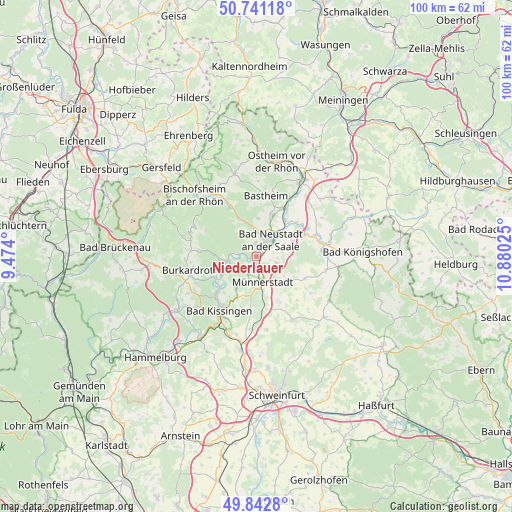
Niederlauer GPS coordinates[2]
50° 17' 38.796" North, 10° 10' 37.632" East
| Map corner | latitude | longitude |
|---|---|---|
| Upper-left | 50.74118°, | 9.474° |
| Center: | 50.29411°, | 10.17712° |
| Lower-right: | 49.8428°, | 10.88025° |
| Map W x H: | 99.9×99.9 km | = 62.1×62.1mi |
| max Lat: | 55.01917° ⇑56.9% North |
| Niederlauer: | 50.29411° |
| min Lat: | ⇓43.1% South 47.40724° |
| min Long | Niederlauer | max Long |
| 5.92978° | 10.17712° | 14.98853° |
| W 53%⇐ | ⇒47% E |
Elevation
Elevation of Niederlauer is 239 m = 784 ft, and this is 10.1 m = 33 ft below average elevation for this country.
| Max E: |
1256 m = 4121 ft | 48.1% |
| Avg. | 249.1 m = 817 ft | |
| Niederlauer | 239 m = 784 ft | |
Min E: |
-5 m = -16 ft | 51.9% |
See also: Germany elevation on elevation.city.
Geographical zone
Niederlauer is located in North temperate zone (between Tropic of Cancer and the Arctic Circle). Distance of this North polar circle is 1809 km =1124.1 mi to North.| Distance of | km | miles | from Niederlauer |
|---|---|---|---|
| North Pole | 4414.9 | 2743.3 | to North |
| Arctic Circle | 1809 | 1124.1 | to North |
| Tropic Cancer | 2986.3 | 1855.6 | to South |
| Equator | 5592.2 | 3474.8 | to South |


Nearby cities:
15 places around Niederlauer: (largest is in red/bold)
• Bad Bocklet
7.6 km =4.7 mi,  246°
246°
• Bad Neustadt an der Saale
3.7 km =2.3 mi,  34°
34°
• Bastheim
12 km =7.5 mi,  9°
9°
• Burglauer
2 km =1.2 mi,  175°
175°
• Heustreu
9 km =5.6 mi,  41°
41°
• Hohenroth
2.5 km =1.6 mi, 9°
• Hollstadt
10.7 km =6.6 mi,  54°
54°
• Münnerstadt
5.6 km =3.5 mi,  161°
161°
• Nüdlingen
9 km =5.6 mi,  205°
205°
• Rödelmaier
7.6 km =4.7 mi,  68°
68°
• Salz
2.9 km =1.8 mi,  57°
57°
• Strahlungen
4.2 km =2.6 mi,  106°
106°
• Unsleben
10.9 km =6.8 mi, 29°
• Wollbach
9 km =5.6 mi, 26°
• Wülfershausen
12.4 km =7.7 mi, 70°
Sources, notices
• [Note1] Compared only with cities in Germany existing in our database
• [Src1] Map data: © OpenStreetMap contributors (CC-BY-SA)
• [Src2] Other city data from geonames.org with taken over terms of usage.
• [Src3] Geographical zone / Annual Mean Temperature by Robert A. Rohde @ Wikipedia
