Bastheim geodata
Bastheim (Bavaria) is a seat of a fourth-order administrative division; located in Germany in Europe/Berlin (GMT+2) time zone. With population of 2,689 people, there are 4242 cities with bigger population in this country. Compared to other cities in Germany, 54.5% of cities are located further ↑North; 53.4% of cities are located further ←West and 60.2% of cities have lower elevation than Bastheim. Note1
Administrative division(s):
- Level 1: Bavaria
- Level 2: Regierungsbezirk Unterfranken
- Level 3: Landkreis Rhön-Grabfeld
- Level 4: Bastheim


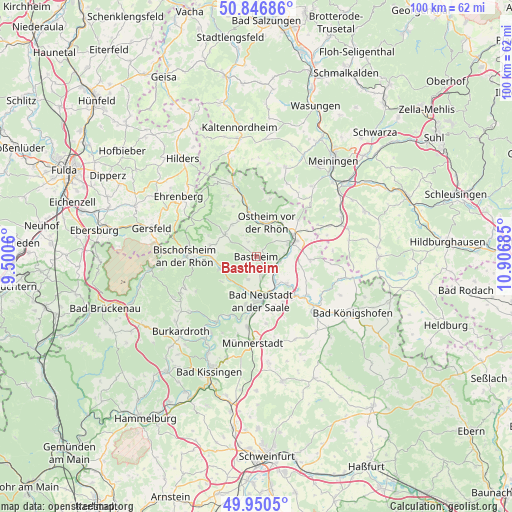
Bastheim GPS coordinates[2]
50° 24' 2.88" North, 10° 12' 13.392" East
| Map corner | latitude | longitude |
|---|---|---|
| Upper-left | 50.84686°, | 9.5006° |
| Center: | 50.4008°, | 10.20372° |
| Lower-right: | 49.9505°, | 10.90685° |
| Map W x H: | 99.7×99.7 km | = 62×62mi |
| max Lat: | 55.01917° ⇑54.5% North |
| Bastheim: | 50.4008° |
| min Lat: | ⇓45.5% South 47.40724° |
| min Long | Bastheim | max Long |
| 5.92978° | 10.20372° | 14.98853° |
| W 53.4%⇐ | ⇒46.6% E |
Elevation
Elevation of Bastheim is 291 m = 955 ft, and this is 41.9 m = 137 ft above average elevation for this country.
| Max E: |
1256 m = 4121 ft | 39.8% |
| Bastheim | 291 m 955 ft | |
| Avg. | 249.1 m = 817 ft | |
Min E: |
-5 m = -16 ft | 60.2% |
See also: Germany elevation on elevation.city.
Geographical zone
Bastheim is located in North temperate zone (between Tropic of Cancer and the Arctic Circle). Distance of this North polar circle is 1797.1 km =1116.7 mi to North.| Distance of | km | miles | from Bastheim |
|---|---|---|---|
| North Pole | 4403 | 2735.9 | to North |
| Arctic Circle | 1797.1 | 1116.7 | to North |
| Tropic Cancer | 2998.1 | 1862.9 | to South |
| Equator | 5604 | 3482.2 | to South |


Nearby cities:
15 places around Bastheim: (largest is in red/bold)
• Bad Neustadt an der Saale
8.8 km =5.5 mi,  178°
178°
• Hendungen
10.5 km =6.5 mi,  93°
93°
• Heustreu
6.5 km =4 mi,  141°
141°
• Hohenroth
9.5 km =5.9 mi,  188°
188°
• Hollstadt
8.9 km =5.5 mi,  129°
129°
• Mellrichstadt
7.7 km =4.8 mi,  66°
66°
• Oberelsbach
7.6 km =4.7 mi,  306°
306°
• Oberstreu
6 km =3.7 mi, 87°
• Ostheim vor der Rhön
6.8 km =4.2 mi,  16°
16°
• Rödelmaier
10.4 km =6.5 mi,  149°
149°
• Salz
10.3 km =6.4 mi, 176°
• Sondheim vor der Rhön
7.9 km =4.9 mi,  335°
335°
• Stockheim
8.2 km =5.1 mi,  36°
36°
• Unsleben
4.2 km =2.6 mi,  124°
124°
• Wollbach
4.3 km =2.7 mi, 151°
Sources, notices
• [Note1] Compared only with cities in Germany existing in our database
• [Src1] Map data: © OpenStreetMap contributors (CC-BY-SA)
• [Src2] Other city data from geonames.org with taken over terms of usage.
• [Src3] Geographical zone / Annual Mean Temperature by Robert A. Rohde @ Wikipedia
