Hohenroth geodata
Hohenroth (Bavaria) is a seat of a fourth-order administrative division; located in Germany in Europe/Berlin (GMT+1) time zone. In our database, there are 11009 cities with bigger population. Compared to other cities in Germany, 56.5% of cities are located further ↑North; 53.1% of cities are located further ←West and 61.1% of cities have lower elevation than Hohenroth. Note1
Administrative division(s):
- Level 1: Bavaria
- Level 2: Regierungsbezirk Unterfranken
- Level 3: Landkreis Rhön-Grabfeld
- Level 4: Hohenroth


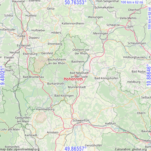
Hohenroth GPS coordinates[2]
50° 19' 0.012" North, 10° 10' 59.988" East
| Map corner | latitude | longitude |
|---|---|---|
| Upper-left | 50.76353°, | 9.48021° |
| Center: | 50.31667°, | 10.18333° |
| Lower-right: | 49.86557°, | 10.88646° |
| Map W x H: | 99.8×99.8 km | = 62×62mi |
| max Lat: | 55.01917° ⇑56.5% North |
| Hohenroth: | 50.31667° |
| min Lat: | ⇓43.5% South 47.40724° |
| min Long | Hohenroth | max Long |
| 5.92978° | 10.18333° | 14.98853° |
| W 53.1%⇐ | ⇒46.9% E |
Elevation
Elevation of Hohenroth is 296 m = 971 ft, and this is 46.9 m = 154 ft above average elevation for this country.
| Max E: |
1256 m = 4121 ft | 38.9% |
| Hohenroth | 296 m 971 ft | |
| Avg. | 249.1 m = 817 ft | |
Min E: |
-5 m = -16 ft | 61.1% |
See also: Germany elevation on elevation.city.
Geographical zone
Hohenroth is located in North temperate zone (between Tropic of Cancer and the Arctic Circle). Distance of this North polar circle is 1806.5 km =1122.5 mi to North.| Distance of | km | miles | from Hohenroth |
|---|---|---|---|
| North Pole | 4412.4 | 2741.7 | to North |
| Arctic Circle | 1806.5 | 1122.5 | to North |
| Tropic Cancer | 2988.8 | 1857.2 | to South |
| Equator | 5594.7 | 3476.4 | to South |


Nearby cities:
15 places around Hohenroth: (largest is in red/bold)
• Bad Bocklet
9.3 km =5.8 mi,  233°
233°
• Bad Neustadt an der Saale
1.8 km =1.1 mi,  71°
71°
• Bastheim
9.5 km =5.9 mi,  8°
8°
• Burglauer
4.5 km =2.8 mi,  183°
183°
• Heustreu
6.9 km =4.3 mi,  52°
52°
• Hollstadt
9.1 km =5.7 mi, 65°
• Münnerstadt
7.9 km =4.9 mi,  170°
170°
• Niederlauer
2.5 km =1.6 mi,  189°
189°
• Nüdlingen
11.5 km =7.1 mi,  201°
201°
• Rödelmaier
6.7 km =4.2 mi,  86°
86°
• Salz
2.2 km =1.4 mi,  114°
114°
• Strahlungen
5.1 km =3.2 mi,  136°
136°
• Unsleben
8.5 km =5.3 mi,  35°
35°
• Wollbach
6.6 km =4.1 mi,  32°
32°
• Wülfershausen
11.3 km =7 mi,  81°
81°
Sources, notices
• [Note1] Compared only with cities in Germany existing in our database
• [Src1] Map data: © OpenStreetMap contributors (CC-BY-SA)
• [Src2] Other city data from geonames.org with taken over terms of usage.
• [Src3] Geographical zone / Annual Mean Temperature by Robert A. Rohde @ Wikipedia
