Nickenich geodata
Nickenich (Rheinland-Pfalz) is a seat of a fourth-order administrative division; located in Germany in Europe/Berlin (GMT+2) time zone. With population of 3,582 people, there are 3552 cities with bigger population in this country. Compared to other cities in Germany, 54.4% of cities are located further ↑North; 89.6% of cities are located further →East and 51% of cities have higher elevation than Nickenich. Note1
Administrative division(s):
- Level 1: Rheinland-Pfalz
- Level 3: Landkreis Mayen-Koblenz
- Level 4: Nickenich


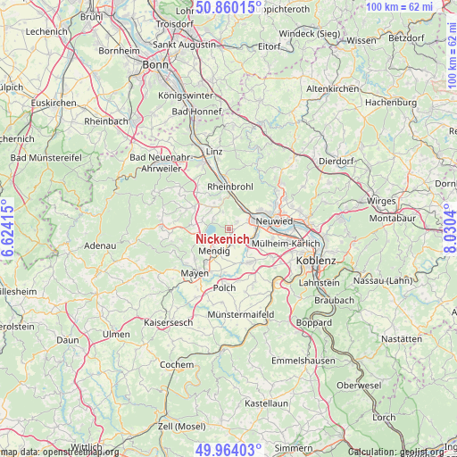
Nickenich GPS coordinates[2]
50° 24' 51.156" North, 7° 19' 38.208" East
| Map corner | latitude | longitude |
|---|---|---|
| Upper-left | 50.86015°, | 6.62415° |
| Center: | 50.41421°, | 7.32728° |
| Lower-right: | 49.96403°, | 8.0304° |
| Map W x H: | 99.6×99.6 km | = 61.9×61.9mi |
| max Lat: | 55.01917° ⇑54.4% North |
| Nickenich: | 50.41421° |
| min Lat: | ⇓45.6% South 47.40724° |
| min Long | Nickenich | max Long |
| 5.92978° | 7.32728° | 14.98853° |
| W 10.4%⇐ | ⇒89.6% E |
Elevation
Elevation of Nickenich is 218 m = 715 ft, and this is 31.1 m = 102 ft below average elevation for this country.
| Max E: |
1256 m = 4121 ft | 51% |
| Avg. | 249.1 m = 817 ft | |
| Nickenich | 218 m = 715 ft | |
Min E: |
-5 m = -16 ft | 49% |
See also: Germany elevation on elevation.city.
Geographical zone
Nickenich is located in North temperate zone (between Tropic of Cancer and the Arctic Circle). Distance of this North polar circle is 1795.6 km =1115.7 mi to North.| Distance of | km | miles | from Nickenich |
|---|---|---|---|
| North Pole | 4401.5 | 2735 | to North |
| Arctic Circle | 1795.6 | 1115.7 | to North |
| Tropic Cancer | 2999.6 | 1863.9 | to South |
| Equator | 5605.5 | 3483.1 | to South |


Nearby cities:
15 places around Nickenich: (largest is in red/bold)
• Andernach
5.8 km =3.6 mi,  71°
71°
• Bell
7.5 km =4.7 mi,  242°
242°
• Brohl-Lützing
7.6 km =4.7 mi,  0°
0°
• Burgbrohl
5.7 km =3.5 mi,  321°
321°
• Glees
5.9 km =3.7 mi,  291°
291°
• Hammerstein
7.9 km =4.9 mi,  11°
11°
• Kretz
3.2 km =2 mi,  129°
129°
• Kruft
3.5 km =2.2 mi,  172°
172°
• Leutesdorf
5.6 km =3.5 mi,  44°
44°
• Mendig
6.1 km =3.8 mi,  210°
210°
• Plaidt
5.2 km =3.2 mi,  117°
117°
• Saffig
7.2 km =4.5 mi, 118°
• Thür
7.3 km =4.5 mi, 209°
• Wassenach
3.8 km =2.4 mi,  304°
304°
• Wehr
7.8 km =4.8 mi,  271°
271°
Sources, notices
• [Note1] Compared only with cities in Germany existing in our database
• [Src1] Map data: © OpenStreetMap contributors (CC-BY-SA)
• [Src2] Other city data from geonames.org with taken over terms of usage.
• [Src3] Geographical zone / Annual Mean Temperature by Robert A. Rohde @ Wikipedia
